
Make a donation
Gear up for your next adventure:
As an Amazon Associate, this site earns from qualifying purchases at no extra cost to you.
Bramel topographic map
Click on the map to display elevation.
Make a donation
Gear up for your next adventure:
As an Amazon Associate, this site earns from qualifying purchases at no extra cost to you.
About this map
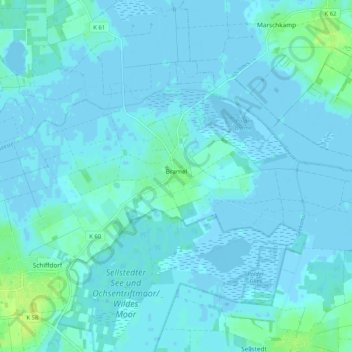
Name: Bramel topographic map, elevation, terrain.
Average elevation: 2 m
Minimum elevation: -4 m
Maximum elevation: 13 m
Make a donation
Gear up for your next adventure:
As an Amazon Associate, this site earns from qualifying purchases at no extra cost to you.
Other topographic maps
Click on a map to view its topography, its elevation and its terrain.
Dorum-Niederstrich
Deutschland > Niedersachsen > Landkreis Cuxhaven > Wurster Nordseeküste > Dorum
Average elevation: 1 m
Cappel-Neufeld
Deutschland > Niedersachsen > Landkreis Cuxhaven > Wurster Nordseeküste
Average elevation: 1 m
Make a donation
Gear up for your next adventure:
As an Amazon Associate, this site earns from qualifying purchases at no extra cost to you.
Altenwalde
Deutschland > Niedersachsen > Landkreis Cuxhaven > Cuxhaven
Auf der Altenwalder Höhe (37,5 m ü. NHN) bestand ein altsächsisches Gräberfeld mit Urnen vom 3. bis 8. Jahrhundert. Das Gelände wurde überbaut mit der fränkisch-karolingischen Altenwalder Burg von vermutlich um 797. Bei der Burg stand eine – möglicherweise schon von Karl dem Großen gestiftete…
Average elevation: 9 m
Dorfhagen
Deutschland > Niedersachsen > Landkreis Cuxhaven > Hagen im Bremischen
Average elevation: 15 m
Make a donation
Gear up for your next adventure:
As an Amazon Associate, this site earns from qualifying purchases at no extra cost to you.
Geversdorf, Niederelbe
Deutschland > Niedersachsen > Landkreis Cuxhaven > Geversdorf, Niederelbe
Average elevation: 0 m
Make a donation
Gear up for your next adventure:
As an Amazon Associate, this site earns from qualifying purchases at no extra cost to you.
Spieka-Neufeld
Deutschland > Niedersachsen > Landkreis Cuxhaven > Wurster Nordseeküste
Average elevation: 1 m
Wittstedt
Deutschland > Niedersachsen > Landkreis Cuxhaven > Hagen im Bremischen
Average elevation: 5 m
Make a donation
Gear up for your next adventure:
As an Amazon Associate, this site earns from qualifying purchases at no extra cost to you.
Berensch
Deutschland > Niedersachsen > Landkreis Cuxhaven > Cuxhaven
Im Wattenvorland westlich von Cuxhaven führten die Berthold Seliger Forschungs- und Entwicklungsgesellschaft mbH und die Hermann-Oberth-Gesellschaft zwischen 1957 und 1964 zahlreiche Raketenstarts durch, wobei einige Raketen der Berthold Seliger Forschungs- und Entwicklungsgesellschaft mbH Gipfelhöhen von…
Average elevation: 7 m
Voßloge
Deutschland > Niedersachsen > Landkreis Cuxhaven > Hagen im Bremischen > Wulsbüttel
Average elevation: 20 m
Make a donation
Gear up for your next adventure:
As an Amazon Associate, this site earns from qualifying purchases at no extra cost to you.
Kleinenhain
Deutschland > Niedersachsen > Landkreis Cuxhaven > Geestland > Lintig
Average elevation: 10 m
Westerwisch
Deutschland > Niedersachsen > Landkreis Cuxhaven > Cuxhaven > Stickenbüttel
Average elevation: 3 m
Make a donation
Gear up for your next adventure:
As an Amazon Associate, this site earns from qualifying purchases at no extra cost to you.
Make a donation
Gear up for your next adventure:
As an Amazon Associate, this site earns from qualifying purchases at no extra cost to you.
Make a donation
Gear up for your next adventure:
As an Amazon Associate, this site earns from qualifying purchases at no extra cost to you.
Harrendorf
Deutschland > Niedersachsen > Landkreis Cuxhaven > Hagen im Bremischen > Bramstedt
Average elevation: 15 m
Siedlung Heuberg
Deutschland > Niedersachsen > Landkreis Cuxhaven > Hagen im Bremischen > Wulsbüttel
Average elevation: 13 m
Make a donation
Gear up for your next adventure:
As an Amazon Associate, this site earns from qualifying purchases at no extra cost to you.
Hosermühlen
Deutschland > Niedersachsen > Landkreis Cuxhaven > Loxstedt > Bexhövede
Average elevation: 5 m
Make a donation
Gear up for your next adventure:
As an Amazon Associate, this site earns from qualifying purchases at no extra cost to you.
Make a donation
Gear up for your next adventure:
As an Amazon Associate, this site earns from qualifying purchases at no extra cost to you.
Dedesdorf-Eidewarden
Deutschland > Niedersachsen > Landkreis Cuxhaven > Loxstedt
Average elevation: 0 m
Make a donation
Gear up for your next adventure:
As an Amazon Associate, this site earns from qualifying purchases at no extra cost to you.
Am Bahnhof
Deutschland > Niedersachsen > Landkreis Cuxhaven > Beverstedt > Frelsdorf
Average elevation: 10 m
Make a donation
Gear up for your next adventure:
As an Amazon Associate, this site earns from qualifying purchases at no extra cost to you.
Make a donation
Gear up for your next adventure:
As an Amazon Associate, this site earns from qualifying purchases at no extra cost to you.
Langenfelde
Deutschland > Niedersachsen > Landkreis Cuxhaven > Beverstedt > Bokel
Average elevation: 10 m
Itzwörden
Deutschland > Niedersachsen > Landkreis Cuxhaven > Cadenberge > Itzwörden
Average elevation: 0 m
Make a donation
Gear up for your next adventure:
As an Amazon Associate, this site earns from qualifying purchases at no extra cost to you.
Vorm Moor
Deutschland > Niedersachsen > Landkreis Cuxhaven > Geestland > Köhlen > Vorm Moor
Average elevation: 6 m
Süderwesterseite
Deutschland > Niedersachsen > Landkreis Cuxhaven > Steinau > Süderwesterseite
Average elevation: 0 m
Norderwesterseite
Deutschland > Niedersachsen > Landkreis Cuxhaven > Steinau > Steinau, Niederelbe > Norderwesterseite
Average elevation: 0 m
Make a donation
Gear up for your next adventure:
As an Amazon Associate, this site earns from qualifying purchases at no extra cost to you.
Osterwanna
Deutschland > Niedersachsen > Landkreis Cuxhaven > Wanna > Osterwanna
Average elevation: 2 m
Make a donation
Gear up for your next adventure:
As an Amazon Associate, this site earns from qualifying purchases at no extra cost to you.
Make a donation
Gear up for your next adventure:
As an Amazon Associate, this site earns from qualifying purchases at no extra cost to you.