
Make a donation
Gear up for your next adventure:
As an Amazon Associate, this site earns from qualifying purchases at no extra cost to you.
Altenwalde topographic map
Click on the map to display elevation.
Make a donation
Gear up for your next adventure:
As an Amazon Associate, this site earns from qualifying purchases at no extra cost to you.
Altenwalde
Auf der Altenwalder Höhe (37,5 m ü. NHN) bestand ein altsächsisches Gräberfeld mit Urnen vom 3. bis 8. Jahrhundert. Das Gelände wurde überbaut mit der fränkisch-karolingischen Altenwalder Burg von vermutlich um 797. Bei der Burg stand eine – möglicherweise schon von Karl dem Großen gestiftete Wallfahrtskapelle des Heiligen Kreuzes und des Willehad. Sie war im 14. Jahrhundert marode und wurde zwischen 1590 und 1629 abgebrochen.
Make a donation
Gear up for your next adventure:
As an Amazon Associate, this site earns from qualifying purchases at no extra cost to you.
About this map
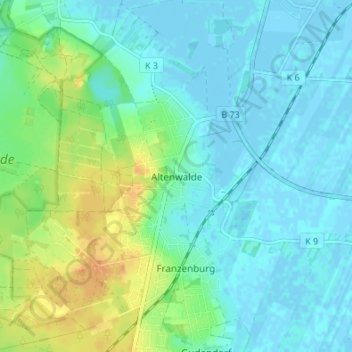
Name: Altenwalde topographic map, elevation, terrain.
Average elevation: 9 m
Minimum elevation: -3 m
Maximum elevation: 31 m
Make a donation
Gear up for your next adventure:
As an Amazon Associate, this site earns from qualifying purchases at no extra cost to you.
Other topographic maps
Click on a map to view its topography, its elevation and its terrain.