
Make a donation
Gear up for your next adventure:
As an Amazon Associate, this site earns from qualifying purchases at no extra cost to you.
Berensch topographic map
Click on the map to display elevation.
Make a donation
Gear up for your next adventure:
As an Amazon Associate, this site earns from qualifying purchases at no extra cost to you.
Berensch
Im Wattenvorland westlich von Cuxhaven führten die Berthold Seliger Forschungs- und Entwicklungsgesellschaft mbH und die Hermann-Oberth-Gesellschaft zwischen 1957 und 1964 zahlreiche Raketenstarts durch, wobei einige Raketen der Berthold Seliger Forschungs- und Entwicklungsgesellschaft mbH Gipfelhöhen von über 100 Kilometern erreicht haben. Weitere Raketenstarts wurden seinerzeit in der Nähe von Arensch durchgeführt.
Make a donation
Gear up for your next adventure:
As an Amazon Associate, this site earns from qualifying purchases at no extra cost to you.
About this map
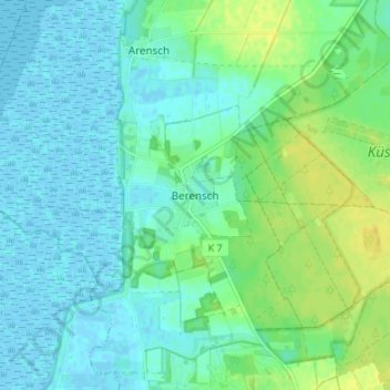
Name: Berensch topographic map, elevation, terrain.
Average elevation: 7 m
Minimum elevation: -2 m
Maximum elevation: 21 m
Make a donation
Gear up for your next adventure:
As an Amazon Associate, this site earns from qualifying purchases at no extra cost to you.
Other topographic maps
Click on a map to view its topography, its elevation and its terrain.