
Make a donation
Gear up for your next adventure:
As an Amazon Associate, this site earns from qualifying purchases at no extra cost to you.
Saas-Fee topographic map
Click on the map to display elevation.
Make a donation
Gear up for your next adventure:
As an Amazon Associate, this site earns from qualifying purchases at no extra cost to you.
Saas-Fee
Saas-Fee offers 22 lifts, including 3 cable cars, 1 funicular railway (Metro Alpin), 5 gondolas (1 dedicated to walkers), 2 chairlifts, the remainder being surface lifts (draglifts). The ski run has a vertical drop of 1,800 m (5,906 ft), a top elevation of 3,600 m (11,811 ft) and covers 150 km (93 mi) (80 km (50 mi) beginner, 45 km (28 mi) intermediate, 25 km (16 mi) advanced). Other activities include paragliding, hang gliding, and tobogganing.
Make a donation
Gear up for your next adventure:
As an Amazon Associate, this site earns from qualifying purchases at no extra cost to you.
About this map
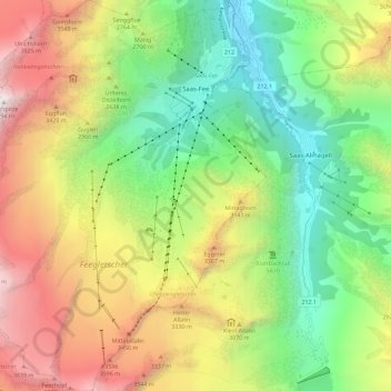
Name: Saas-Fee topographic map, elevation, terrain.
Location: Saas-Fee, Visp, Wallis, 3906, Switzerland (46.04609 7.85721 46.12524 7.94542)
Average elevation: 2,673 m
Minimum elevation: 1,560 m
Maximum elevation: 4,272 m
Make a donation
Gear up for your next adventure:
As an Amazon Associate, this site earns from qualifying purchases at no extra cost to you.
Other topographic maps
Click on a map to view its topography, its elevation and its terrain.
Furi
Switzerland > Wallis > Visp > Zermatt
Furi is an alpine hamlet in the Pennine Alps, located three kilometers south of Zermatt, Switzerland at an altitude of 1,687m. It is located on a relatively flat area of land between the Gornera and Zmuttbach rivers.
Average elevation: 2,206 m
Make a donation
Gear up for your next adventure:
As an Amazon Associate, this site earns from qualifying purchases at no extra cost to you.
Monte Rosa
Switzerland > Wallis > Visp > Zermatt
The peak is distinguished by the name Dufourspitze (in German, lit. Dufour Peak; French: Pointe Dufour, Italian: Punta Dufour). This replaced the former name Höchste Spitze (English: Highest Peak) that was indicated on the Swiss maps before the Federal Council, on January 28, 1863, decided to rename the…
Average elevation: 4,033 m
Make a donation
Gear up for your next adventure:
As an Amazon Associate, this site earns from qualifying purchases at no extra cost to you.
Make a donation
Gear up for your next adventure:
As an Amazon Associate, this site earns from qualifying purchases at no extra cost to you.