Geolocate

Stafel topographic map

Click on the map to display elevation.

About this map

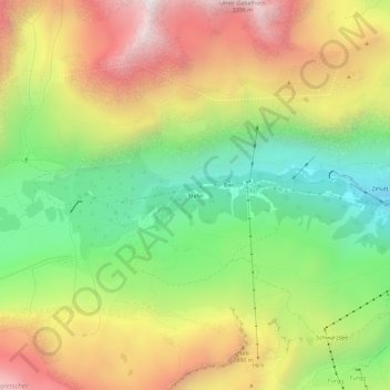
Name: Stafel topographic map, elevation, terrain.

Location: Stafel, Zermatt, Visp, Wallis, 3920, Switzerland (45.98577 7.66985 46.02577 7.70985)

Average elevation: 2,545 m

Minimum elevation: 1,878 m

Maximum elevation: 3,326 m

Other topographic maps

Click on a map to view its topography, its elevation and its terrain.

Gorner Glacier

Switzerland > Wallis > Visp > Zermatt

Average elevation: 3,179 m

Gear up for your next adventure:

🧊Insulated Water Bottle - Keeps drinks cold in summer and prevents freezing in winter
🧦Crew Hiking Socks - Comfortable socks for long-distance hikes
🍽️Titanium Camping Spork - Ultralight and indestructible eating utensil
🧣Evaporative Cooling Towel - Beat the heat during intense summer climbs
🛌Insulated Sleeping Pad - Critical thermal barrier between you and the cold ground

As an Amazon Associate, this site earns from qualifying purchases at no extra cost to you.