Geolocate

Dom topographic map

Click on the map to display elevation.

About this map

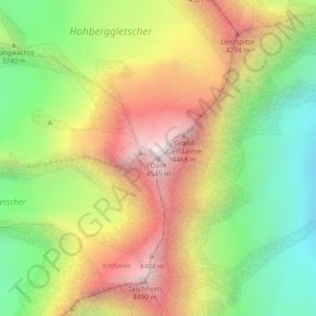
Name: Dom topographic map, elevation, terrain.

Location: Dom, Saas-Fee, Visp, Wallis, 3906, Switzerland (46.09388 7.85882 46.09398 7.85892)

Average elevation: 3,785 m

Minimum elevation: 3,113 m

Maximum elevation: 4,538 m

Gear up for your next adventure:

🛶Canoe Life Vest - Safety vest for water sports
Camping Tent - Weather-resistant tents suitable for 2 to 6 people
🔦LED Headtorch - Bright and durable light for night activities
🥾Waterproof Hiking Boots - Essential footwear for rugged terrain and wet Canadian trails
🥾Hiking Shorts - Breathable shorts suitable for summer hikes

As an Amazon Associate, this site earns from qualifying purchases at no extra cost to you.