Geolocate

Angrogna topographic map

Click on the map to display elevation.

About this map

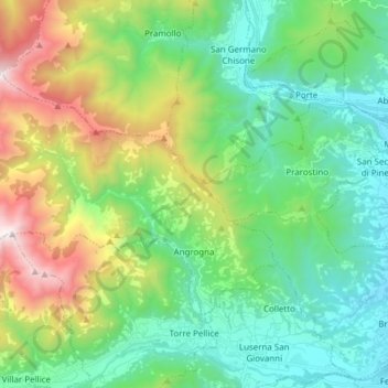
Name: Angrogna topographic map, elevation, terrain.

Location: Angrogna, Turin, Piedmont, Italy (44.82603 7.10396 44.89318 7.25663)

Average elevation: 918 m

Minimum elevation: 375 m

Maximum elevation: 2,250 m

Other topographic maps

Click on a map to view its topography, its elevation and its terrain.

Prarotto

Italy > Piedmont > Turin > Condove

Average elevation: 1,190 m

Turin

Italy > Piedmont > Turin

Average elevation: 295 m

Blanc

Italy > Piedmont > Turin > San Germano Chisone

Average elevation: 831 m

Turin

Italy > Piedmont > Turin

Average elevation: 295 m

Sportinia

Italy > Piedmont > Turin > Sauze d'Oulx

Average elevation: 2,015 m

La Cialma

Italy > Piedmont > Turin > Locana

Average elevation: 1,705 m

Pratobotrile

Italy > Piedmont > Turin > Condove

Average elevation: 1,117 m

Turin

Italy > Piedmont > Turin

Average elevation: 295 m

Rivetto

Italy > Piedmont > Turin > San Giorio di Susa

Average elevation: 583 m

Magnoletto

Italy > Piedmont > Turin > Condove

Average elevation: 699 m

Suppo

Italy > Piedmont > Turin > Rubiana

Average elevation: 1,350 m

Tornetti

Italy > Piedmont > Turin > Viù

Average elevation: 1,333 m

Baio Dora

Italy > Piedmont > Turin

Average elevation: 494 m

Famolasco

Italy > Piedmont > Turin

Average elevation: 508 m

Morelli

Italy > Piedmont > Turin > Gravere

Average elevation: 785 m

Belvedere

Italy > Piedmont > Turin > Borgiallo

Average elevation: 733 m

Gear up for your next adventure:

🧭GPS Outdoor Watch - Smart watch for navigation and fitness tracking in nature
🧣Merino Neck Gaiter - Protects against wind, sun, and cold at high altitudes
👟Leg Gaiters - Keep debris, mud, and snow out of your boots
🐕Hiking Dog Pack - Let your canine companion carry their own water and food
🧥Waterproof Hiking Jacket - Protect yourself from rain and wind while hiking

As an Amazon Associate, this site earns from qualifying purchases at no extra cost to you.