
Make a donation
Gear up for your next adventure:
As an Amazon Associate, this site earns from qualifying purchases at no extra cost to you.
Premeno topographic map
Click on the map to display elevation.
Make a donation
Gear up for your next adventure:
As an Amazon Associate, this site earns from qualifying purchases at no extra cost to you.
Premeno
Die Fraktion Esio (im lokalen Dialekt Ies), auf einer Höhe von 700 m ü. M. gelegen, ist der Weiler von Premeno, der sich am weitesten vom historischen Zentrum entfernt ist; er bildete bis zur 1. Hälfte des 20. Jahrhunderts eine eigenständige Gemeinde. Das Dorf wurde um das 17. Jahrhundert als eigenständige Gemeinde gegründet und hat im Laufe ihrer Geschichte nie den Einfluss des Tourismus gespürt. Bis Anfang 20. Jahrhundert waren hier mehrere Tavernen, in denen die Wanderer, die das Tal durchquerten, untergebracht wurden. Das Dorf hat etwa 150–200 Einwohner und besteht aus Steinhäusern und engen Gassen.
Make a donation
Gear up for your next adventure:
As an Amazon Associate, this site earns from qualifying purchases at no extra cost to you.
About this map
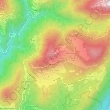
Name: Premeno topographic map, elevation, terrain.
Location: Premeno, Verbano-Cusio-Ossola, Piemont, Italien (45.96560 8.57455 46.00027 8.62048)
Average elevation: 745 m
Minimum elevation: 294 m
Maximum elevation: 1,175 m
Make a donation
Gear up for your next adventure:
As an Amazon Associate, this site earns from qualifying purchases at no extra cost to you.
Other topographic maps
Click on a map to view its topography, its elevation and its terrain.
Westalpen
Italien > Piemont > Verbano-Cusio-Ossola > Ceppo Morelli
Die Westalpen enthalten die gesamten Alpenanteile von Frankreich und Monaco, den größten der Schweiz, sowie einen nicht unbeträchtlichen von Italien, und sind insgesamt deutlich höher als die Ostalpen – 81 der insgesamt 82 Viertausender der Alpen liegen in den Westalpen, und damit auch die 64 höchsten…
Average elevation: 2,662 m
Make a donation
Gear up for your next adventure:
As an Amazon Associate, this site earns from qualifying purchases at no extra cost to you.
Valdo / Wald
Italien > Piemont > Verbano-Cusio-Ossola > Pomatt > Ponte / Zum Schtäg
Average elevation: 1,843 m
Make a donation
Gear up for your next adventure:
As an Amazon Associate, this site earns from qualifying purchases at no extra cost to you.
Mottarone
Italien > Piemont > Verbano-Cusio-Ossola > Stresa
Der Berg ist seit 1970 durch die zweiteilige Luftseilbahn „Funivia Stresa-Alpino-Mottarone“ erschlossen, die von der Baufirma Impresa Poscio und der Bahnbaufirma Piemonte Funivie in Turin errichtet wurde. Von Oktober 2014 bis 12. August 2016 war der Betrieb wegen Instandsetzungsarbeiten eingestellt. Die…
Average elevation: 1,177 m
Make a donation
Gear up for your next adventure:
As an Amazon Associate, this site earns from qualifying purchases at no extra cost to you.
Fontana dell' Albi
Italien > Piemont > Verbano-Cusio-Ossola > Pieve Vergonte
Average elevation: 1,344 m
Make a donation
Gear up for your next adventure:
As an Amazon Associate, this site earns from qualifying purchases at no extra cost to you.
Make a donation
Gear up for your next adventure:
As an Amazon Associate, this site earns from qualifying purchases at no extra cost to you.
Alpe Corti
Italien > Piemont > Verbano-Cusio-Ossola > Montescheno > Alpi Faiu
Average elevation: 1,274 m
Make a donation
Gear up for your next adventure:
As an Amazon Associate, this site earns from qualifying purchases at no extra cost to you.