Geolocate

Darlington topographic map

Click on the map to display elevation.

About this map

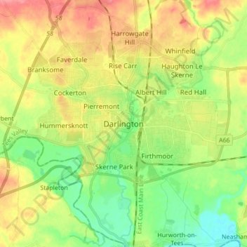
Name: Darlington topographic map, elevation, terrain.

Location: Darlington, Tees Valley, England, DL1 5PW, United Kingdom (54.48421 -1.59558 54.56421 -1.51558)

Average elevation: 52 m

Minimum elevation: 21 m

Maximum elevation: 90 m

Other topographic maps

Click on a map to view its topography, its elevation and its terrain.

Sadberge

United Kingdom > England > Darlington

Average elevation: 53 m

Barmpton

United Kingdom > England > Darlington

Average elevation: 65 m

Hurworth

United Kingdom > England > Darlington

Average elevation: 39 m

Piercebridge

United Kingdom > England > Darlington

Average elevation: 69 m

Neasham

United Kingdom > England > Darlington

Average elevation: 38 m

Bishopton

United Kingdom > England > Darlington

Average elevation: 54 m

Heighington

United Kingdom > England > Darlington

Average elevation: 116 m

High Coniscliffe

United Kingdom > England > Darlington

Average elevation: 63 m

Great Burdon

United Kingdom > England > Darlington

Average elevation: 54 m

Gear up for your next adventure:

🎒Hiking Backpack - Lightweight and ergonomic backpacks for day hikes or multi-day treks
Backpacking Tent - Lightweight tent for long-distance hiking trips
🧢Sun Protection Cap - Breathable cap to protect from sun exposure
🥾Mountain Hiking Boots - High-traction boots for rocky terrain
🪑Insulated Seat Pad - Protect your seat from cold rocks and wet logs

As an Amazon Associate, this site earns from qualifying purchases at no extra cost to you.