Geolocate

Sadberge topographic map

Click on the map to display elevation.

About this map

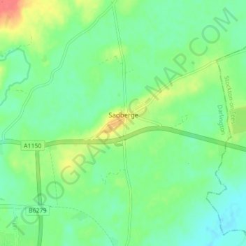
Name: Sadberge topographic map, elevation, terrain.

Location: Sadberge, Darlington, Tees Valley, England, United Kingdom (54.52513 -1.49357 54.56553 -1.44257)

Average elevation: 53 m

Minimum elevation: 36 m

Maximum elevation: 87 m

Other topographic maps

Click on a map to view its topography, its elevation and its terrain.

Darlington

United Kingdom > England > Darlington

Average elevation: 52 m

Blackwell

United Kingdom > England > Darlington

Average elevation: 46 m

Darlington

United Kingdom > England > Darlington

Average elevation: 52 m

Darlington

United Kingdom > England > Darlington

Average elevation: 52 m

Gear up for your next adventure:

🧥Packable Rain Jacket - Breathable waterproof layer for unpredictable weather
💧Hydration Bladder - Hands-free hydration solution for long treks
Camping Tent - Weather-resistant tents suitable for 2 to 6 people
🥫Freeze-Dried Meals - Lightweight, high-calorie nutrition for multi-day treks
🧰Survival Kit - Essential gear for emergencies in the wilderness

As an Amazon Associate, this site earns from qualifying purchases at no extra cost to you.