Geolocate

Heighington topographic map

Click on the map to display elevation.

About this map

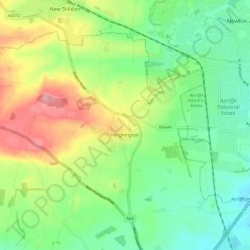
Name: Heighington topographic map, elevation, terrain.

Location: Heighington, Darlington, Tees Valley, England, United Kingdom (54.57660 -1.68241 54.61936 -1.58376)

Average elevation: 116 m

Minimum elevation: 67 m

Maximum elevation: 200 m

Other topographic maps

Click on a map to view its topography, its elevation and its terrain.

Blackwell

United Kingdom > England > Darlington

Average elevation: 46 m

Darlington

United Kingdom > England > Darlington

Average elevation: 52 m

Darlington

United Kingdom > England > Darlington

Average elevation: 52 m

Darlington

United Kingdom > England > Darlington

Average elevation: 52 m

Gear up for your next adventure:

🧤Insulated Winter Gloves - Heavy-duty protection for sub-zero Canadian adventures
🧥Waterproof Jacket - Lightweight rain jackets for hiking and outdoor activities
🧥Ultralight Puffy Jacket - Maximum warmth that packs down to the size of an orange
🛶Kayak Dry Bag - Waterproof storage for kayaking adventures
🥾Waterproof Hiking Boots - Essential footwear for rugged terrain and wet Canadian trails

As an Amazon Associate, this site earns from qualifying purchases at no extra cost to you.