Geolocate

Piercebridge topographic map

Click on the map to display elevation.

About this map

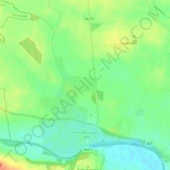
Name: Piercebridge topographic map, elevation, terrain.

Location: Piercebridge, Darlington, Tees Valley, England, United Kingdom (54.53333 -1.70526 54.55642 -1.67180)

Average elevation: 69 m

Minimum elevation: 49 m

Maximum elevation: 97 m

Other topographic maps

Click on a map to view its topography, its elevation and its terrain.

Darlington

United Kingdom > England > Darlington

Average elevation: 52 m

Blackwell

United Kingdom > England > Darlington

Average elevation: 46 m

Darlington

United Kingdom > England > Darlington

Average elevation: 52 m

Darlington

United Kingdom > England > Darlington

Average elevation: 52 m

Gear up for your next adventure:

🛶Kayak Accessories - Essential gear for safe and fun kayaking adventures
🛏️Sleeping Bag - Warm and compact sleeping bags for outdoor camping
🔭Outdoor Binoculars - Lightweight binoculars for birdwatching and hiking
🦶Hiking Shoe Insoles - Added support for high arches and long days on feet
🧳Compression Sacks - Maximize space in your backpack by shrinking gear

As an Amazon Associate, this site earns from qualifying purchases at no extra cost to you.