Geolocate

Silda topographic map

Click on the map to display elevation.

About this map

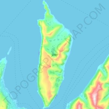
Name: Silda topographic map, elevation, terrain.

Location: Silda, Troms og Finnmark, Norway (70.25953 21.67766 70.39303 21.80958)

Average elevation: 90 m

Minimum elevation: -39 m

Maximum elevation: 1,013 m

Other topographic maps

Click on a map to view its topography, its elevation and its terrain.

Nord-Lenangen

Norway > Troms og Finnmark

Average elevation: 52 m

Lyngseidet

Norway > Troms og Finnmark

Average elevation: 181 m

Stordalen

Norway > Troms og Finnmark > Tromsø > Stordalen

Average elevation: 150 m

Gear up for your next adventure:

🧢Hiking Hat - Sun-protective and breathable hats for long treks
🔭Outdoor Binoculars - Lightweight binoculars for birdwatching and hiking
❄️Traction Ice Cleats - Slip-on spikes for icy trails and winter hiking
🪑Insulated Seat Pad - Protect your seat from cold rocks and wet logs
🧶550 Survival Paracord - Versatile utility cord for emergency repairs and rigging

As an Amazon Associate, this site earns from qualifying purchases at no extra cost to you.