Geolocate

Sommarsetet topographic map

Click on the map to display elevation.

About this map

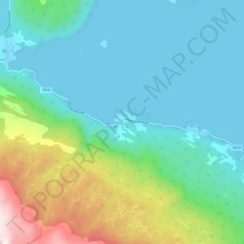
Name: Sommarsetet topographic map, elevation, terrain.

Location: Sommarsetet, Salangen, Troms og Finnmark, Norway (68.85043 17.71890 68.89043 17.75890)

Average elevation: 141 m

Minimum elevation: 0 m

Maximum elevation: 609 m

Other topographic maps

Click on a map to view its topography, its elevation and its terrain.

Senja

Norway > Troms og Finnmark

Average elevation: 122 m

Gratangen

Norway > Troms og Finnmark

Average elevation: 350 m

Hasvik

Norway > Troms og Finnmark

Average elevation: 52 m

Kvænangen

Norway > Troms og Finnmark

Average elevation: 447 m

Silda

Norway > Troms og Finnmark

Average elevation: 90 m

South Varanki

Norway > Troms og Finnmark

Average elevation: 150 m

Hersøya

Norway > Troms og Finnmark

Average elevation: 22 m

Gear up for your next adventure:

🧭GPS Tracker - Track your location in remote areas safely
🛶Canoe Life Vest - Safety vest for water sports
🚲Handlebar Phone Mount - View topographic-map.com live while cycling
🧦Crew Hiking Socks - Comfortable socks for long-distance hikes
🛌Down Sleeping Bag - Superior warmth-to-weight ratio for cold nights

As an Amazon Associate, this site earns from qualifying purchases at no extra cost to you.