Geolocate

Abadín topographic map

Click on the map to display elevation.

Abadín

Abadín is situated in the north-east of Terra Chá. The municipality is crossed by the Serra do Xistral, the Cordal de Neda, and the rivers Labrada and Abadín. The mean elevation is of 500 m, and the highest point is Lombo Pequeno at 1015 m.

Wikipedia (CC-BY-SA 3.0)

About this map

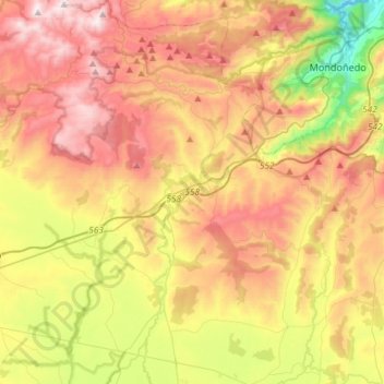
Name: Abadín topographic map, elevation, terrain.

Location: Abadín, Terra Chá, Lugo, Galicia, Spain (43.25371 -7.59507 43.46663 -7.37759)

Average elevation: 547 m

Minimum elevation: 59 m

Maximum elevation: 1,029 m

Other topographic maps

Click on a map to view its topography, its elevation and its terrain.

Bistixoán

Spain > Galicia > Terra Chá > Guitiriz

Average elevation: 541 m

Cádavas

Spain > Galicia > Terra Chá > Vilalba

Average elevation: 438 m

Fra

Spain > Galicia > Terra Chá > Vilalba

Average elevation: 474 m

Muimenta

Spain > Galicia > Terra Chá

Average elevation: 417 m

Cabanacomba

Spain > Galicia > Terra Chá > Guitiriz

Average elevation: 598 m

Os Castros

Spain > Galicia > Terra Chá > Vilalba

Average elevation: 527 m

Outeiro

Spain > Galicia > Terra Chá > Castro de Rei

Average elevation: 428 m

Gear up for your next adventure:

🔪Outdoor Multitool - Versatile tool for repairs and food prep in the wild
🥾Durable Hiking Shoes - Long-lasting shoes for frequent hiking
🧥Waterproof Jacket - Lightweight rain jackets for hiking and outdoor activities
❄️Traction Ice Cleats - Slip-on spikes for icy trails and winter hiking
🪑Insulated Seat Pad - Protect your seat from cold rocks and wet logs

As an Amazon Associate, this site earns from qualifying purchases at no extra cost to you.