Geolocate

Fra topographic map

Click on the map to display elevation.

About this map

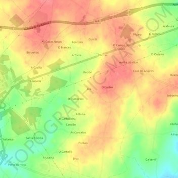
Name: Fra topographic map, elevation, terrain.

Location: Fra, Goiriz, Vilalba, Terra Chá, Lugo, Galicia, 27840, Spain (43.28829 -7.65441 43.32829 -7.61441)

Average elevation: 474 m

Minimum elevation: 429 m

Maximum elevation: 504 m

Other topographic maps

Click on a map to view its topography, its elevation and its terrain.

Vilapedre

Spain > Galicia > Terra Chá > Vilalba

Average elevation: 634 m

Gear up for your next adventure:

🎒Backpack Rain Cover - External shield to keep your entire pack dry
🥾Trail Running Boots - Durable shoes designed for trail running
🥾Mountain Trail Shoes - High-traction shoes for mountain trails
🥘Camping Cookware Set - Compact nesting pots and pans for trail cooking
🌬️Windproof Camp Stove - Efficient cooking even on exposed mountain peaks

As an Amazon Associate, this site earns from qualifying purchases at no extra cost to you.