Geolocate

Larvik topographic map

Click on the map to display elevation.

About this map

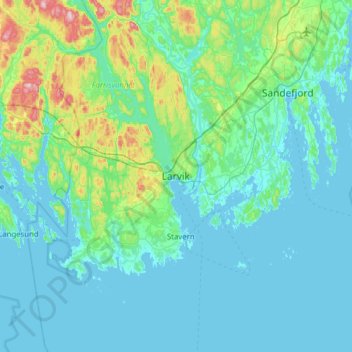
Name: Larvik topographic map, elevation, terrain.

Location: Larvik, Vestfold og Telemark, 3256, Norway (58.89317 9.86718 59.21317 10.18718)

Average elevation: 45 m

Minimum elevation: -1 m

Maximum elevation: 348 m

Other topographic maps

Click on a map to view its topography, its elevation and its terrain.

Bordalsvatn

Norway > Vestfold og Telemark

Average elevation: 1,017 m

Midt-Telemark

Norway > Vestfold og Telemark

Average elevation: 360 m

Fyresdal

Norway > Vestfold og Telemark

Average elevation: 693 m

Nissedal

Norway > Vestfold og Telemark

Average elevation: 500 m

Kviteseid

Norway > Vestfold og Telemark

Average elevation: 594 m

Gear up for your next adventure:

🛏️Sleeping Bag - Warm and compact sleeping bags for outdoor camping
🩹Compact First Aid Kit - Pre-packed essentials for common trail injuries
🥾Hiking Shorts - Breathable shorts suitable for summer hikes
🧢Sun Protection Cap - Breathable cap to protect from sun exposure
🧰Multitool Knife - Compact and versatile tool for outdoor use

As an Amazon Associate, this site earns from qualifying purchases at no extra cost to you.