Geolocate

Gap Lake topographic map

Click on the map to display elevation.

About this map

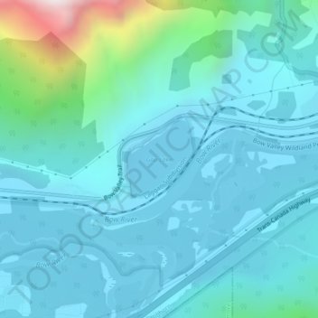
Name: Gap Lake topographic map, elevation, terrain.

Location: Gap Lake, Municipal District of Bighorn, Alberta, Canada (51.05120 -115.23832 51.05782 -115.22819)

Average elevation: 1,424 m

Minimum elevation: 1,287 m

Maximum elevation: 2,253 m

Municipal District of Bighorn trails, hiking, mountain biking, running and outdoor activities

Other topographic maps

Click on a map to view its topography, its elevation and its terrain.

Exshaw

Canada > Alberta > Municipal District of Bighorn

Average elevation: 1,420 m

Waiparous

Canada > Alberta > Municipal District of Bighorn

Average elevation: 1,338 m

Gear up for your next adventure:

Tent Footprint - Protect tent floor and increase durability
🧦Merino Wool Socks - Moisture-wicking comfort for long-distance hiking
Camping Coffee Maker - Brew fresh coffee anywhere on the topographic map
💡LED Camping Lantern - Illuminate your campsite with long-lasting lanterns
🧢Hiking Sun Hat - Wide-brimmed protection for exposed mountain ridges

As an Amazon Associate, this site earns from qualifying purchases at no extra cost to you.