Geolocate

Penne topographic map

Click on the map to display elevation.

About this map

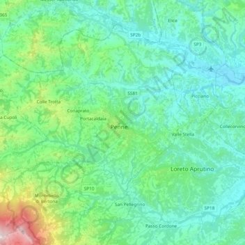
Name: Penne topographic map, elevation, terrain.

Location: Penne, Pescara, Abruzzo, 65017, Italy (42.40487 13.79347 42.51628 13.98070)

Average elevation: 294 m

Minimum elevation: 61 m

Maximum elevation: 1,296 m

Other topographic maps

Click on a map to view its topography, its elevation and its terrain.

Cugnoli

Italy > Abruzzo > Pescara > Turrivalignani

Average elevation: 203 m

Traino

Italy > Abruzzo > Pescara > Villa Celiera

Average elevation: 917 m

Chianchiro

Italy > Abruzzo > Pescara > Villa Cupoli

Average elevation: 511 m

La Maielletta

Italy > Abruzzo > Pescara > Roccamorice

Average elevation: 1,694 m

11

Italy > Abruzzo > Pescara > Brittoli > Boragne

Average elevation: 603 m

Pagliari

Italy > Abruzzo > Pescara > Roccamorice

Average elevation: 623 m

Fonte Tettone

Italy > Abruzzo > Pescara > Roccamorice

Average elevation: 1,507 m

Vestea

Italy > Abruzzo > Pescara

Average elevation: 540 m

Gear up for your next adventure:

🥾Waterproof Trail Shoes - Shoes designed to handle wet terrain
🧰Emergency Multi-Tool - Compact multi-tool for outdoor survival
🔭Compact Monocular - One-handed bird watching and trail spotting
🧴Bear Spray Holster - Quick-access carry for essential Canadian wilderness safety
🛌Insulated Sleeping Pad - Critical thermal barrier between you and the cold ground

As an Amazon Associate, this site earns from qualifying purchases at no extra cost to you.