
Make a donation
Gear up for your next adventure:
As an Amazon Associate, this site earns from qualifying purchases at no extra cost to you.
Carinthia topographic map
Click on the map to display elevation.
Make a donation
Gear up for your next adventure:
As an Amazon Associate, this site earns from qualifying purchases at no extra cost to you.
About this map
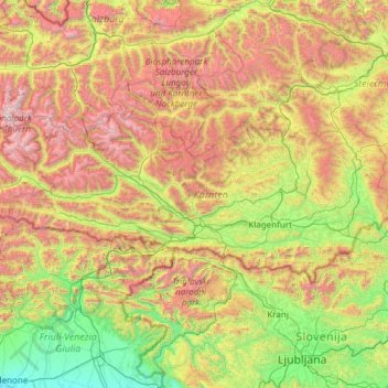
Name: Carinthia topographic map, elevation, terrain.
Location: Carinthia, Austria (46.37230 12.65683 47.13130 15.06515)
Average elevation: 1,095 m
Minimum elevation: 16 m
Maximum elevation: 3,652 m
Make a donation
Gear up for your next adventure:
As an Amazon Associate, this site earns from qualifying purchases at no extra cost to you.
Other topographic maps
Click on a map to view its topography, its elevation and its terrain.
Lahnberg
Austria > Lower Austria > Bezirk Neunkirchen > Schwarzau im Gebirge
Average elevation: 1,213 m
Make a donation
Gear up for your next adventure:
As an Amazon Associate, this site earns from qualifying purchases at no extra cost to you.
Klagenfurt Land
Austria > Carinthia > Bezirk Klagenfurt-Land > Krumpendorf am Wörthersee
Average elevation: 894 m
Bad Eisenkappel/Železna Kapla
Austria > Carinthia > Bezirk Völkermarkt > Eisenkappel-Vellach
Average elevation: 914 m
Make a donation
Gear up for your next adventure:
As an Amazon Associate, this site earns from qualifying purchases at no extra cost to you.
Make a donation
Gear up for your next adventure:
As an Amazon Associate, this site earns from qualifying purchases at no extra cost to you.