
Thank you for supporting this site ❤️
Make a donation
Make a donation
Gear up for your next adventure:
As an Amazon Associate, this site earns from qualifying purchases at no extra cost to you.
Khudi topographic map
Click on the map to display elevation.
Thank you for supporting this site ❤️
Make a donation
Make a donation
Gear up for your next adventure:
As an Amazon Associate, this site earns from qualifying purchases at no extra cost to you.
About this map
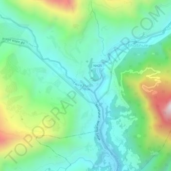
Name: Khudi topographic map, elevation, terrain.
Location: Khudi, Marsyangdi, Lamjung, Gandaki Province, 33600, Nepal (28.26098 84.33762 28.30098 84.37762)
Average elevation: 1,064 m
Minimum elevation: 744 m
Maximum elevation: 1,894 m
Thank you for supporting this site ❤️
Make a donation
Make a donation
Gear up for your next adventure:
As an Amazon Associate, this site earns from qualifying purchases at no extra cost to you.