Geolocate

Gilbert topographic map

Click on the map to display elevation.

About this map

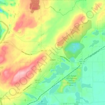
Name: Gilbert topographic map, elevation, terrain.

Location: Gilbert, Saint Louis County, Minnesota, United States (47.45681 -92.50616 47.53133 -92.43312)

Average elevation: 472 m

Minimum elevation: 402 m

Maximum elevation: 566 m

Other topographic maps

Click on a map to view its topography, its elevation and its terrain.

Toivola

United States > Minnesota > Saint Louis County

Average elevation: 392 m

Hibbing

United States > Minnesota > Saint Louis County > Hibbing > Hibbing

Average elevation: 454 m

Canyon

United States > Minnesota > Saint Louis County > Canyon

Average elevation: 411 m

Whiteface

United States > Minnesota > Saint Louis County

Average elevation: 418 m

City park

United States > Minnesota > Saint Louis County > Duluth

Average elevation: 206 m

Gheen

United States > Minnesota > Saint Louis County > Gheen

Average elevation: 411 m

Munger

United States > Minnesota > Saint Louis County > Munger

Average elevation: 416 m

Cotton

United States > Minnesota > Saint Louis County > Cotton

Average elevation: 405 m

Gear up for your next adventure:

🧦Outdoor Socks - Durable socks designed for hiking and outdoor sports
🧥Thermal Layer - Insulating layer for cold outdoor conditions
💧Filtered Water Bottle - Safe drinking water on the go
🥾Mountaineering Boots - Supportive boots for climbing and high-altitude hiking
🧤Thermal Hiking Gloves - Grip-enhanced gloves for cold-weather altitude trekking

As an Amazon Associate, this site earns from qualifying purchases at no extra cost to you.