Geolocate

Munger topographic map

Click on the map to display elevation.

About this map

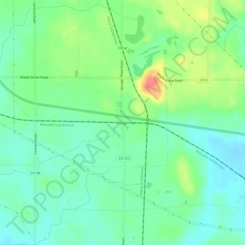
Name: Munger topographic map, elevation, terrain.

Location: Munger, Saint Louis County, Minnesota, United States (46.78078 -92.36380 46.82078 -92.32380)

Average elevation: 416 m

Minimum elevation: 394 m

Maximum elevation: 462 m

Gear up for your next adventure:

❄️Traction Ice Cleats - Slip-on spikes for icy trails and winter hiking
🔋Lithium AA Batteries - Long-lasting power that performs in extreme cold
🥾Light Hiking Boots - Lightweight and comfortable boots for day hikes
🚑Survival Whistle - Signal for help across long distances in mountains
🥾Trekking Boots - Durable boots for long-distance trekking

As an Amazon Associate, this site earns from qualifying purchases at no extra cost to you.