
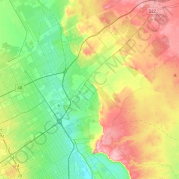
Al Naseem Municipality topographic map
Interactive map
Click on the map to display elevation.
About this map
Name: Al Naseem Municipality topographic map, elevation, terrain.
Average elevation: 624 m
Minimum elevation: 566 m
Maximum elevation: 713 m
Other topographic maps
Click on a map to view its topography, its elevation and its terrain.
Riyadh
Riyadh has a hot desert climate (Köppen Climate Classification BWh), with long, extremely hot summers and short, very mild winters. The average high temperature in August is 43.6 °C (110.5 °F). If it was not for the elevation the city was on, Riyadh would experience an even hotter climate. The city…
Average elevation: 630 m
Riyadh
Riyadh has a hot desert climate (Köppen Climate Classification BWh), with long, extremely hot summers and short, very mild winters. The average high temperature in July is 43.9 °C (111.0 °F). If not for its elevation Riyadh would experience an even hotter climate. The city experiences very little…
Average elevation: 630 m
Riyadh
Riyadh has a hot desert climate (Köppen Climate Classification BWh), with long, extremely hot summers and short, very mild winters. The average high temperature in August is 43.6 °C (110.5 °F). If it was not for the elevation the city was on, Riyadh would experience an even hotter climate. The city…
Average elevation: 630 m
Riyadh
Riyadh has a hot desert climate (Köppen Climate Classification BWh), with long, extremely hot summers and short, very mild winters. The average high temperature in August is 43.6 °C (110.5 °F). If not for the elevation the city was on, Riyadh would experience an even hotter climate. The city experiences…
Average elevation: 630 m