Geolocate

Muras topographic map

Click on the map to display elevation.

About this map

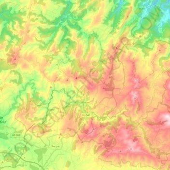
Name: Muras topographic map, elevation, terrain.

Location: Muras, Terra Chá, Lugo, Galicia, 27837, Spain (43.41414 -7.78429 43.55685 -7.54404)

Average elevation: 553 m

Minimum elevation: 152 m

Maximum elevation: 995 m

Other topographic maps

Click on a map to view its topography, its elevation and its terrain.

Bistixoán

Spain > Galicia > Terra Chá > Guitiriz

Average elevation: 541 m

Cádavas

Spain > Galicia > Terra Chá > Vilalba

Average elevation: 438 m

Fra

Spain > Galicia > Terra Chá > Vilalba

Average elevation: 474 m

Muimenta

Spain > Galicia > Terra Chá

Average elevation: 417 m

Cabanacomba

Spain > Galicia > Terra Chá > Guitiriz

Average elevation: 598 m

Os Castros

Spain > Galicia > Terra Chá > Vilalba

Average elevation: 527 m

Outeiro

Spain > Galicia > Terra Chá > Castro de Rei

Average elevation: 428 m

Gear up for your next adventure:

🧊Portable Cooler - Keep food and drinks cold during outdoor adventures
🧢Sun Protection Cap - Breathable cap to protect from sun exposure
Family Camping Tent - Spacious tent suitable for family camping trips
🥾Waterproof Trail Shoes - Shoes designed to handle wet terrain
🔋Solar Power Bank - Keep your GPS and devices charged during long outdoor trips

As an Amazon Associate, this site earns from qualifying purchases at no extra cost to you.