Geolocate

Anawalt topographic map

Click on the map to display elevation.

About this map

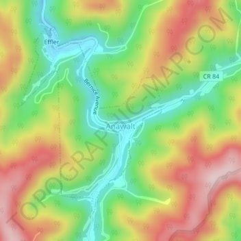
Name: Anawalt topographic map, elevation, terrain.

Location: Anawalt, McDowell County, West Virginia, United States (37.32612 -81.45058 37.34704 -81.43074)

Average elevation: 643 m

Minimum elevation: 498 m

Maximum elevation: 810 m

Other topographic maps

Click on a map to view its topography, its elevation and its terrain.

Squire

United States > West Virginia > McDowell County

Average elevation: 635 m

Rift

United States > West Virginia > McDowell County

Average elevation: 553 m

Faraday

United States > West Virginia > McDowell County

Average elevation: 639 m

Vivian

United States > West Virginia > McDowell County

Average elevation: 619 m

English

United States > West Virginia > McDowell County

Average elevation: 558 m

Ennis

United States > West Virginia > McDowell County

Average elevation: 730 m

Carswell

United States > West Virginia > McDowell County

Average elevation: 606 m

Atwell

United States > West Virginia > McDowell County

Average elevation: 559 m

Worth

United States > West Virginia > McDowell County

Average elevation: 731 m

Yerba

United States > West Virginia > McDowell County

Average elevation: 563 m

Faraday

United States > West Virginia > McDowell County > Faraday

Average elevation: 639 m

Gear up for your next adventure:

🥾Light Hiking Boots - Lightweight and comfortable boots for day hikes
Camping Essentials - All-in-one gear for a comfortable camping trip
💧Reusable Water Bottle - Durable water bottles for hydration on trails
🎒Backpack Rain Cover - External shield to keep your entire pack dry
🕯️Camping Lantern - Illuminates your entire campsite with high-efficiency LEDs

As an Amazon Associate, this site earns from qualifying purchases at no extra cost to you.