
Make a donation
Gear up for your next adventure:
As an Amazon Associate, this site earns from qualifying purchases at no extra cost to you.
La Pampa topographic map
Click on the map to display elevation.
Make a donation
Gear up for your next adventure:
As an Amazon Associate, this site earns from qualifying purchases at no extra cost to you.
La Pampa
Being located in the Pampas, the province has a cool temperate climate. In general, the province is dominated by two different types of climates: a temperate one in the east and a semi-arid one in the west. Precipitation generally decreases from east to west and from north to south. Being characterized by large thermal amplitudes, the climate of the province has continental characteristics, particularly in the west where thermal amplitudes are much larger. The general atmospheric circulation is one of the most important factors that influence the climate on a regional scale. During summer, the South Atlantic High is displaced to the southeast, which brings hot and humid air masses from the north and northeast. The South Pacific High in summer is responsible for bringing cooler air masses from the southwest which when these two contrasting air masses meet lead to precipitation occurring. In contrast, winters are dry due to the northward displacement of the South Atlantic high and the topographic barrier of the Andes north of 40oS which prevents frontal systems that bring precipitation from reaching the province. Any winds from the southwest during winter bring in cold and dry weather since most of the precipitation and humidity are released in the Andes. As such, most of the precipitation occurs during summer.
Make a donation
Gear up for your next adventure:
As an Amazon Associate, this site earns from qualifying purchases at no extra cost to you.
About this map
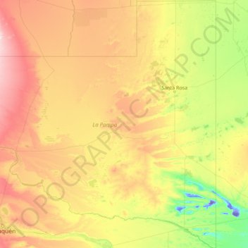
Name: La Pampa topographic map, elevation, terrain.
Location: La Pampa, Argentina (-39.32980 -68.29677 -35.00226 -63.38313)
Average elevation: 299 m
Minimum elevation: -45 m
Maximum elevation: 2,617 m
Make a donation
Gear up for your next adventure:
As an Amazon Associate, this site earns from qualifying purchases at no extra cost to you.
Other topographic maps
Click on a map to view its topography, its elevation and its terrain.
Cordoba
Argentina > Córdoba > Pedanía Capital
The wealthier suburbs west of the city are located at slightly higher altitudes, which allows cool breezes to blow in the summer, bringing drier, comfortable nights during hotter periods, and more regular frost in the winter. Generally speaking, Córdoba's daytime temperatures are very slightly warmer than…
Average elevation: 457 m
Aconcagua
Argentina > Mendoza > Distrito Las Cuevas
Aconcagua (Spanish pronunciation: [akoŋˈkaɣwa]) is a mountain in the Principal Cordillera of the Andes mountain range, in Mendoza Province, Argentina. It is the highest mountain in the Americas, the highest outside Asia, and the highest in the Southern Hemisphere with a summit elevation of 6,961 metres…
Average elevation: 6,201 m
Make a donation
Gear up for your next adventure:
As an Amazon Associate, this site earns from qualifying purchases at no extra cost to you.
Make a donation
Gear up for your next adventure:
As an Amazon Associate, this site earns from qualifying purchases at no extra cost to you.
Colomé
Colomé is a village and rural municipality in Salta Province in northwestern Argentina. It is located about 20 km from Molinos, Salta. This settlement was established by the last Spanish governor of Salta, Nicolás Severo de Isasmendi, in 1831. His daughter Ascención imported grapevines from France and…
Average elevation: 2,292 m
Make a donation
Gear up for your next adventure:
As an Amazon Associate, this site earns from qualifying purchases at no extra cost to you.
Observatorio Las Punillas
Argentina > Córdoba > Pedanía Alta Gracia > Alta Gracia
Average elevation: 566 m
Andes
Argentina > Mendoza > Distrito Las Cuevas
The Andes Mountains are the highest mountain range outside Asia. The highest mountain outside Asia, Argentina's Mount Aconcagua, rises to an elevation of about 6,961 m (22,838 ft) above sea level. The peak of Chimborazo in the Ecuadorian Andes is farther from the Earth's center than any other location on the…
Average elevation: 6,208 m
Make a donation
Gear up for your next adventure:
As an Amazon Associate, this site earns from qualifying purchases at no extra cost to you.
Aconcagua
Argentina > Mendoza > Distrito Las Cuevas
Aconcagua (Spanish pronunciation: [akoŋˈkaɣwa]) is a mountain in the Principal Cordillera of the Andes mountain range, in Mendoza Province, Argentina. It is the highest mountain in the Americas, the highest outside Asia, and the highest in the Southern Hemisphere with a summit elevation of 6,961 metres…
Average elevation: 6,201 m
Aconcagua
Argentina > Mendoza > Distrito Las Cuevas
Aconcagua (Spanish pronunciation: [akoŋˈkaɣwa]) is a mountain in the Principal Cordillera of the Andes mountain range, in Mendoza Province, Argentina. It is the highest mountain in the Americas, the highest outside Asia, and the highest in both the Western Hemisphere and the Southern Hemisphere with a…
Average elevation: 6,201 m
Make a donation
Gear up for your next adventure:
As an Amazon Associate, this site earns from qualifying purchases at no extra cost to you.
Puente del Inca
Argentina > Mendoza > Departamento Luján de Cuyo > Puente del Inca
Situated at 2,744 m (9,003 ft) above sea level, Puente del Inca has a warm-summer mediterranean continental climate (Dsb, according to the Köppen climate classification), as at least 4 months see an average temperature above 10 °C (50 °F) and at least one month sees an average temperature below 0 °C (32…
Average elevation: 3,006 m
Make a donation
Gear up for your next adventure:
As an Amazon Associate, this site earns from qualifying purchases at no extra cost to you.
Make a donation
Gear up for your next adventure:
As an Amazon Associate, this site earns from qualifying purchases at no extra cost to you.
Monte Pissis
Argentina > Catamarca > Municipio de Fiambalá
A 1994 Argentine expedition claimed —using GPS technology available at the time— that the elevation of Monte Pissis was 6,882 m (22,579 ft), higher than Ojos del Salado. Ten years later, with the use of higher precision systems, several other surveys proved that those measurements were inaccurate: in 2005,…
Average elevation: 6,465 m
Make a donation
Gear up for your next adventure:
As an Amazon Associate, this site earns from qualifying purchases at no extra cost to you.
San Juan
San Juan is ranked second among the wine-producing provinces of Argentina. It has a cultivated area of 116,700 acres at altitudes of between 1,970 (601m) and 4,590 feet (1399m) above sea level. This region specializes in Syrah, Malbec, Cabernet Sauvignon, Bonarda, Chardonnay and Torrontés. Because of this…
Average elevation: 694 m
Aconcagua
Argentina > Mendoza > Distrito Las Cuevas
Aconcagua (Spanish pronunciation: [akoŋˈkaɣwa]) is a mountain in the Principal Cordillera of the Andes mountain range, in Mendoza Province, Argentina. It is the highest mountain in the Americas, the highest outside Asia, and the highest in both the Western Hemisphere and the Southern Hemisphere with a…
Average elevation: 6,201 m
Make a donation
Gear up for your next adventure:
As an Amazon Associate, this site earns from qualifying purchases at no extra cost to you.
Las Leñas
Argentina > Mendoza > Distrito Ciudad de Malargüe
Las Leñas is a ski resort in Argentina, located in the western part of Mendoza Province. It has reliable powder snow and climate for extreme and off-piste skiing. Construction of the ski center began January 1983, and by July 1983, it opened with a 300 bed hotel. The ski area has a good diversity of slopes…
Average elevation: 2,393 m
Make a donation
Gear up for your next adventure:
As an Amazon Associate, this site earns from qualifying purchases at no extra cost to you.
Make a donation
Gear up for your next adventure:
As an Amazon Associate, this site earns from qualifying purchases at no extra cost to you.
Make a donation
Gear up for your next adventure:
As an Amazon Associate, this site earns from qualifying purchases at no extra cost to you.
Make a donation
Gear up for your next adventure:
As an Amazon Associate, this site earns from qualifying purchases at no extra cost to you.
Make a donation
Gear up for your next adventure:
As an Amazon Associate, this site earns from qualifying purchases at no extra cost to you.
Make a donation
Gear up for your next adventure:
As an Amazon Associate, this site earns from qualifying purchases at no extra cost to you.
Aconcagua
Argentina > Mendoza > Distrito Las Cuevas
Aconcagua (Spanish pronunciation: [akoŋˈkaɣwa]) is a mountain in the Principal Cordillera of the Andes mountain range, in Mendoza Province, Argentina. It is the highest mountain in the Americas, the highest outside Asia, and the highest in both the Western Hemisphere and the Southern Hemisphere with a…
Average elevation: 6,201 m
Make a donation
Gear up for your next adventure:
As an Amazon Associate, this site earns from qualifying purchases at no extra cost to you.
Make a donation
Gear up for your next adventure:
As an Amazon Associate, this site earns from qualifying purchases at no extra cost to you.
Make a donation
Gear up for your next adventure:
As an Amazon Associate, this site earns from qualifying purchases at no extra cost to you.
Make a donation
Gear up for your next adventure:
As an Amazon Associate, this site earns from qualifying purchases at no extra cost to you.
Make a donation
Gear up for your next adventure:
As an Amazon Associate, this site earns from qualifying purchases at no extra cost to you.
Make a donation
Gear up for your next adventure:
As an Amazon Associate, this site earns from qualifying purchases at no extra cost to you.
Aconcagua
Argentina > Mendoza > Distrito Las Cuevas
Aconcagua (Spanish pronunciation: [akoŋˈkaɣwa]) is a mountain in the Principal Cordillera of the Andes mountain range, in Mendoza Province, Argentina. It is the highest mountain in the Americas, the highest outside Asia, and the highest in the Southern Hemisphere with a summit elevation of 6,961 metres…
Average elevation: 6,201 m
Make a donation
Gear up for your next adventure:
As an Amazon Associate, this site earns from qualifying purchases at no extra cost to you.
Make a donation
Gear up for your next adventure:
As an Amazon Associate, this site earns from qualifying purchases at no extra cost to you.
José León Suárez
Argentina > Buenos Aires > José León Suárez > José León Suárez
Average elevation: 17 m
Make a donation
Gear up for your next adventure:
As an Amazon Associate, this site earns from qualifying purchases at no extra cost to you.
Make a donation
Gear up for your next adventure:
As an Amazon Associate, this site earns from qualifying purchases at no extra cost to you.