
Make a donation
Gear up for your next adventure:
As an Amazon Associate, this site earns from qualifying purchases at no extra cost to you.
Trelew topographic map
Click on the map to display elevation.
Make a donation
Gear up for your next adventure:
As an Amazon Associate, this site earns from qualifying purchases at no extra cost to you.
About this map
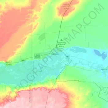
Name: Trelew topographic map, elevation, terrain.
Average elevation: 71 m
Minimum elevation: 0 m
Maximum elevation: 218 m
Make a donation
Gear up for your next adventure:
As an Amazon Associate, this site earns from qualifying purchases at no extra cost to you.
Other topographic maps
Click on a map to view its topography, its elevation and its terrain.
Municipio de Esquel
Owing to its location on the immediate leeward side of the Andes, Esquel has a cool summer Mediterranean climate (Köppen Csb) bordering on a Humid continental climate (Köppen Dsb). Other climate systems, such as the Trewartha climate classification, place it within the oceanic zone (Do), like much of Western…
Average elevation: 965 m
Municipio de Trevelin
Trevelin has a temperate oceanic climate (Köppen Cfb), but with a rainfall pattern similar to the Mediterranean climate (Köppen Csb). The climate is milder than that of other locations on the Argentine side of Northern Patagonia because of the low altitude and the direct exposure to Pacific winds. This…
Average elevation: 941 m
Make a donation
Gear up for your next adventure:
As an Amazon Associate, this site earns from qualifying purchases at no extra cost to you.
Valdes Peninsula
Most of the peninsula is barren land with some salt lakes. The largest of these lakes has an elevation of about 40 m below sea level (see extremes on Earth), until recently thought to be the lowest elevation in Argentina and South America (the lowest point actually being Laguna del Carbón, Argentina, which is…
Average elevation: 28 m
Municipio de Esquel
Owing to its location on the immediate leeward side of the Andes, Esquel has a cool summer Mediterranean climate (Köppen Csb) bordering on a Humid continental climate (Köppen Dsb). Other climate systems, such as the Trewartha climate classification, place it within the oceanic zone (Do), like much of Western…
Average elevation: 965 m
Make a donation
Gear up for your next adventure:
As an Amazon Associate, this site earns from qualifying purchases at no extra cost to you.
Valdes Peninsula
Most of the peninsula is barren land with some salt lakes. The largest of these lakes has an elevation of about 40 m below sea level (see extremes on Earth), until recently thought to be the lowest elevation in Argentina and South America (the lowest point actually being Laguna del Carbón, Argentina, which is…
Average elevation: 28 m
Make a donation
Gear up for your next adventure:
As an Amazon Associate, this site earns from qualifying purchases at no extra cost to you.
Municipio de Esquel
Owing to its location on the immediate leeward side of the Andes, Esquel has a cool summer Mediterranean climate (Köppen Csb) bordering on a Humid continental climate (Köppen Dsb). Other climate systems, such as the Trewartha climate classification, place it within the oceanic zone (Do), like much of Western…
Average elevation: 965 m
Make a donation
Gear up for your next adventure:
As an Amazon Associate, this site earns from qualifying purchases at no extra cost to you.