
Barry topographic map
Click on the map to display elevation.
About this map
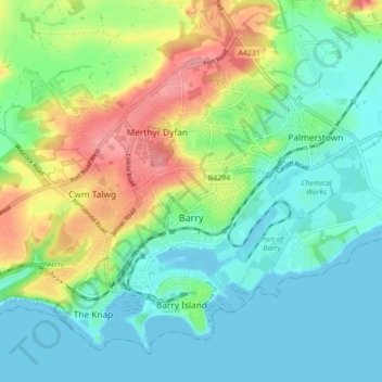
Name: Barry topographic map, elevation, terrain.
Location: Barry, Vale of Glamorgan, Wales, United Kingdom (51.38482 -3.31846 51.43143 -3.23094)
Average elevation: 29 m
Minimum elevation: 0 m
Maximum elevation: 93 m
Other topographic maps
Click on a map to view its topography, its elevation and its terrain.
Peterston-super-Ely
United Kingdom > Wales > Vale of Glamorgan > Peterston-super-Ely
Average elevation: 57 m
Bonvilston
United Kingdom > Wales > Vale of Glamorgan
In the 19th century, Richard Bassett, a prominent figure in Glamorgan resided at Bonvilston House and owned the manor. The 1811 A Topographical Dictionary of The Dominion of Wales by Nicholas Carlisle said of the village.
Average elevation: 83 m
Cosmeston Lakes Country Park
United Kingdom > Wales > Vale of Glamorgan > Penarth
Average elevation: 26 m