Geolocate

Treoes topographic map

Click on the map to display elevation.

About this map

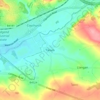
Name: Treoes topographic map, elevation, terrain.

Location: Treoes, Vale of Glamorgan, Wales, CF35 5DL, United Kingdom (51.47443 -3.54246 51.51443 -3.50246)

Average elevation: 46 m

Minimum elevation: 11 m

Maximum elevation: 117 m

Other topographic maps

Click on a map to view its topography, its elevation and its terrain.

Penarth

United Kingdom > Wales > Vale of Glamorgan

Average elevation: 17 m

Dinas Powys

United Kingdom > Wales > Vale of Glamorgan

Average elevation: 30 m

Barry

United Kingdom > Wales > Vale of Glamorgan

Average elevation: 29 m

St. Athan

United Kingdom > Wales > Vale of Glamorgan > St Athan

Average elevation: 30 m

Romilly Park

United Kingdom > Wales > Vale of Glamorgan > Barry

Average elevation: 26 m

Barry

United Kingdom > Wales > Vale of Glamorgan

Average elevation: 29 m

Barry

United Kingdom > Wales > Vale of Glamorgan

Average elevation: 29 m

Barry

United Kingdom > Wales > Vale of Glamorgan

Average elevation: 29 m

Gear up for your next adventure:

🐕Hiking Dog Pack - Let your canine companion carry their own water and food
💧Hydration Pack - Hands-free hydration system for long hikes
🧤Thermal Hiking Gloves - Grip-enhanced gloves for cold-weather altitude trekking
🧦Hiking Liner Socks - Thin base layer to prevent friction and blisters
🧥Softshell Jacket - Windproof and breathable jacket for hiking

As an Amazon Associate, this site earns from qualifying purchases at no extra cost to you.