Geolocate

Penmark topographic map

Click on the map to display elevation.

About this map

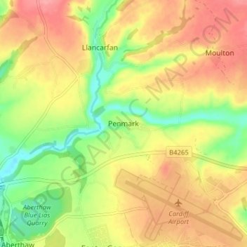
Name: Penmark topographic map, elevation, terrain.

Location: Penmark, Vale of Glamorgan, Wales, CF62 3BQ, United Kingdom (51.39075 -3.37891 51.43075 -3.33891)

Average elevation: 49 m

Minimum elevation: 4 m

Maximum elevation: 87 m

Other topographic maps

Click on a map to view its topography, its elevation and its terrain.

Penarth

United Kingdom > Wales > Vale of Glamorgan

Average elevation: 17 m

Barry

United Kingdom > Wales > Vale of Glamorgan

Average elevation: 29 m

Dinas Powys

United Kingdom > Wales > Vale of Glamorgan

Average elevation: 30 m

St. Athan

United Kingdom > Wales > Vale of Glamorgan > St Athan

Average elevation: 30 m

Romilly Park

United Kingdom > Wales > Vale of Glamorgan > Barry

Average elevation: 26 m

Barry

United Kingdom > Wales > Vale of Glamorgan

Average elevation: 29 m

Barry

United Kingdom > Wales > Vale of Glamorgan

Average elevation: 29 m

Barry

United Kingdom > Wales > Vale of Glamorgan

Average elevation: 29 m

Gear up for your next adventure:

🧥Packable Rain Jacket - Breathable waterproof layer for unpredictable weather
🩹Compact First Aid Kit - Pre-packed essentials for common trail injuries
🧢Beanie Hat - Keep your head warm in cold weather
🛶Canoe Life Vest - Safety vest for water sports
🛰️Satellite Messenger - Emergency communication for areas with no cell service

As an Amazon Associate, this site earns from qualifying purchases at no extra cost to you.