
McBride topographic map
Click on the map to display elevation.
About this map
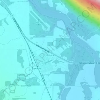
Name: McBride topographic map, elevation, terrain.
Average elevation: 727 m
Minimum elevation: 700 m
Maximum elevation: 1,026 m
Other topographic maps
Click on a map to view its topography, its elevation and its terrain.
Crooked River
Canada > British Columbia > Regional District of Fraser-Fort George > Area G (Crooked River/Parsnip)
Average elevation: 749 m
Carp Lake
Canada > British Columbia > Regional District of Fraser-Fort George > Area G (Crooked River/Parsnip)
Average elevation: 865 m
Mount Tabor
Canada > British Columbia > Regional District of Fraser-Fort George > Area D (Tabor Lake/Stone Creek)
Average elevation: 1,119 m
Mount Robson
Canada > British Columbia > Regional District of Fraser-Fort George > Area H (Robson Valley/Canoe)
The north face can be seen from Berg Lake, and reached by a 19 km (11.8 mi) hike. The lake is approximately 2 km long and lies at 1,646 m (5,400 ft) elevation. There are backcountry campgrounds at each end of the lake and a log shelter on its banks, named Hargreaves Shelter in honor of the Hargreaves family…
Average elevation: 3,037 m
Narrow Lake
Canada > British Columbia > Regional District of Fraser-Fort George > Area F (Willow River/Upper Fraser)
Average elevation: 1,251 m
Punchaw Lake
Canada > British Columbia > Regional District of Fraser-Fort George > Area C (Chilako River/Nechako)
Average elevation: 788 m
Red Rock
Canada > British Columbia > Regional District of Fraser-Fort George > Area D (Tabor Lake/Stone Creek)
Average elevation: 651 m
Eddy
Canada > British Columbia > Regional District of Fraser-Fort George > Area H (Robson Valley/Canoe)
Average elevation: 729 m
Goat River
Canada > British Columbia > Regional District of Fraser-Fort George > Area H (Robson Valley/Canoe)
Average elevation: 705 m
Prince George
Canada > British Columbia > Regional District of Fraser-Fort George > Prince George
Average elevation: 708 m
Willow River
Canada > British Columbia > Regional District of Fraser-Fort George > Area F (Willow River/Upper Fraser)
Average elevation: 621 m
Mugaha Marsh
Canada > British Columbia > Regional District of Fraser-Fort George > Area G (Crooked River/Parsnip)
Average elevation: 681 m
Cottonwood Island Park
Canada > British Columbia > Regional District of Fraser-Fort George > Prince George
Average elevation: 586 m
Hixon
Canada > British Columbia > Regional District of Fraser-Fort George > Area E (Woodpecker/Hixon)
Average elevation: 683 m
Bear Lake
Canada > British Columbia > Regional District of Fraser-Fort George > Area G (Crooked River/Parsnip)
Average elevation: 726 m
Tête Jaune Cache
Canada > British Columbia > Regional District of Fraser-Fort George > Area H (Robson Valley/Canoe)
Average elevation: 789 m
Aleza Lake
Canada > British Columbia > Regional District of Fraser-Fort George > Area F (Willow River/Upper Fraser)
Average elevation: 646 m
Fraserview
Canada > British Columbia > Regional District of Fraser-Fort George > Prince George
Average elevation: 590 m
Mount St. Patrick
Canada > British Columbia > Regional District of Fraser-Fort George > Area F (Willow River/Upper Fraser)
Average elevation: 2,290 m
Salmon Lake
Canada > British Columbia > Regional District of Fraser-Fort George > Area G (Crooked River/Parsnip)
Average elevation: 909 m
Hansard Lake
Canada > British Columbia > Regional District of Fraser-Fort George > Area F (Willow River/Upper Fraser)
Average elevation: 639 m
Rocky Mountains
Canada > British Columbia > Regional District of Fraser-Fort George > Area F (Willow River/Upper Fraser)
Average elevation: 1,252 m
Whitehorn Mountain
Canada > British Columbia > Regional District of Fraser-Fort George > Area H (Robson Valley/Canoe)
Average elevation: 2,553 m
Raven Lake
Canada > British Columbia > Regional District of Fraser-Fort George > Area F (Willow River/Upper Fraser)
Average elevation: 1,630 m
Mount Sir Wilfrid Laurier
Canada > British Columbia > Regional District of Fraser-Fort George > Area H (Robson Valley/Canoe)
Average elevation: 2,900 m
Cariboo Mountains
Canada > British Columbia > Regional District of Fraser-Fort George > Area H (Robson Valley/Canoe)
Average elevation: 2,447 m
Woodpecker
Canada > British Columbia > Regional District of Fraser-Fort George > Area E (Woodpecker/Hixon)
Average elevation: 720 m
Mount Robson
Canada > British Columbia > Regional District of Fraser-Fort George > Area H (Robson Valley/Canoe)
The north face can be seen from Berg Lake, and reached by a 19 km (12 mi) hike. The lake is approximately 2 km long and lies at 1,646 m (5,400 ft) elevation. There are backcountry campgrounds at each end of the lake and a log shelter on its banks, named Hargreaves Shelter in honor of the Hargreaves family who…
Average elevation: 3,037 m
McLeod Lake
Canada > British Columbia > Regional District of Fraser-Fort George > Area G (Crooked River/Parsnip)
A point in the marshes on its southern shore of nearby Summit Lake marks the low point of the divide between the drainages of the Fraser and Peace Rivers, As such it is significant as the prominence col between all points south in the Rockies and beyond and their "parent" summits in northern BC and Alaska.…
Average elevation: 701 m
Coyote Lake
Canada > British Columbia > Regional District of Fraser-Fort George > Area G (Crooked River/Parsnip)
Average elevation: 849 m
Mount Robson
Canada > British Columbia > Regional District of Fraser-Fort George > Area H (Robson Valley/Canoe)
The north face can be seen from Berg Lake, and reached by a 19 km (12 mi) hike. The lake is approximately 2 km long and lies at 1,646 m (5,400 ft) elevation. There are backcountry campgrounds at each end of the lake and a log shelter on its banks, named Hargreaves Shelter in honor of the Hargreaves family who…
Average elevation: 3,042 m
Brûlé Lake
Canada > British Columbia > Regional District of Fraser-Fort George > Area A (Salmon River/Lakes)
Average elevation: 780 m
Whitehorn Mountain
Canada > British Columbia > Regional District of Fraser-Fort George > Area H (Robson Valley/Canoe)
Average elevation: 2,553 m
Rocky Mountains
Canada > British Columbia > Regional District of Fraser-Fort George > Area F (Willow River/Upper Fraser)
Average elevation: 1,421 m
Mount Robson
Canada > British Columbia > Regional District of Fraser-Fort George > Area H (Robson Valley/Canoe)
The north face can be seen from Berg Lake, and reached by a 19 km (12 mi) hike. The lake is approximately 2 km long and lies at 1,646 m (5,400 ft) elevation. There are backcountry campgrounds at each end of the lake and a log shelter on its banks, named Hargreaves Shelter in honor of the Hargreaves family who…
Average elevation: 3,042 m