Geolocate

Williamsdale topographic map

Click on the map to display elevation.

About this map

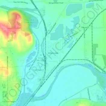
Name: Williamsdale topographic map, elevation, terrain.

Location: Williamsdale, St. Clair Township, Butler County, Ohio, 45055, United States (39.42117 -84.54995 39.46117 -84.50995)

Average elevation: 193 m

Minimum elevation: 173 m

Maximum elevation: 255 m

Other topographic maps

Click on a map to view its topography, its elevation and its terrain.

Middletown

United States > Ohio > Butler County

Average elevation: 215 m

Millville

United States > Ohio > Butler County

Average elevation: 207 m

Somerville

United States > Ohio > Butler County

Average elevation: 256 m

Oxford Township

United States > Ohio > Butler County

The highest point in Butler County, altitude 1,051 feet (320 m), is in Oxford Township.

Average elevation: 289 m

Ross Township

United States > Ohio > Butler County

Average elevation: 211 m

Oxford

United States > Ohio > Butler County

Average elevation: 279 m

Hamilton

United States > Ohio > Butler County

Average elevation: 210 m

Liberty Township

United States > Ohio > Butler County

Average elevation: 234 m

Wayne Township

United States > Ohio > Butler County

Average elevation: 261 m

Lemon Township

United States > Ohio > Butler County

Average elevation: 208 m

Monroe

United States > Ohio > Butler County

Average elevation: 221 m

Olde West Chester

United States > Ohio > Butler County

Average elevation: 227 m

Fairfield Township

United States > Ohio > Butler County

Fairfield Township's name is reflective of the gentle topography in the township. It is one of seven Fairfield Townships statewide.

Average elevation: 207 m

Hanover Township

United States > Ohio > Butler County

Average elevation: 245 m

Madison Township

United States > Ohio > Butler County

Average elevation: 229 m

Trenton

United States > Ohio > Butler County

Average elevation: 200 m

Middletown

United States > Ohio > Butler County

Average elevation: 215 m

Oxford

United States > Ohio > Butler County

Average elevation: 279 m

Wetherington

United States > Ohio > Butler County > Wetherington

Average elevation: 261 m

Hamilton

United States > Ohio > Butler County

Average elevation: 210 m

Olde West Chester

United States > Ohio > Butler County

Average elevation: 227 m

Gear up for your next adventure:

🥾Mountain Trail Shoes - High-traction shoes for mountain trails
🧦Hiking Socks - Moisture-wicking and comfortable socks for long hikes
🧰Survival Kit - Essential gear for emergencies in the wilderness
🥾Durable Hiking Shoes - Long-lasting shoes for frequent hiking
🪑Insulated Seat Pad - Protect your seat from cold rocks and wet logs

As an Amazon Associate, this site earns from qualifying purchases at no extra cost to you.