Geolocate

Hamilton topographic map

Click on the map to display elevation.

About this map

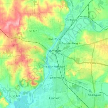
Name: Hamilton topographic map, elevation, terrain.

Location: Hamilton, Butler County, Ohio, United States (39.33450 -84.63024 39.45728 -84.49108)

Average elevation: 210 m

Minimum elevation: 163 m

Maximum elevation: 303 m

Other topographic maps

Click on a map to view its topography, its elevation and its terrain.

South Highlands

United States > Ohio > Butler County > Middletown

Average elevation: 214 m

Busenbark

United States > Ohio > Butler County

Average elevation: 202 m

Hughes

United States > Ohio > Butler County

Average elevation: 237 m

Maud

United States > Ohio > Butler County

Average elevation: 253 m

Williamsdale

United States > Ohio > Butler County

Average elevation: 193 m

McGonigle

United States > Ohio > Butler County

Average elevation: 266 m

Astoria

United States > Ohio > Butler County

Average elevation: 263 m

West Chester

United States > Ohio > Butler County > West Chester

Average elevation: 231 m

Gear up for your next adventure:

🔭Outdoor Binoculars - Lightweight binoculars for birdwatching and hiking
Camping Essentials - All-in-one gear for a comfortable camping trip
💡Solar Camping Lamp - Eco-friendly lighting for campsites
🧣Evaporative Cooling Towel - Beat the heat during intense summer climbs
🪑Insulated Seat Pad - Protect your seat from cold rocks and wet logs

As an Amazon Associate, this site earns from qualifying purchases at no extra cost to you.