Geolocate

Millville topographic map

Click on the map to display elevation.

About this map

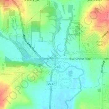
Name: Millville topographic map, elevation, terrain.

Location: Millville, Ross Township, Butler County, Ohio, United States (39.38382 -84.66439 39.40076 -84.64605)

Average elevation: 207 m

Minimum elevation: 184 m

Maximum elevation: 253 m

Other topographic maps

Click on a map to view its topography, its elevation and its terrain.

South Highlands

United States > Ohio > Butler County > Middletown

Average elevation: 214 m

Hughes

United States > Ohio > Butler County

Average elevation: 237 m

Busenbark

United States > Ohio > Butler County

Average elevation: 202 m

Williamsdale

United States > Ohio > Butler County

Average elevation: 193 m

McGonigle

United States > Ohio > Butler County

Average elevation: 266 m

Astoria

United States > Ohio > Butler County

Average elevation: 263 m

West Chester

United States > Ohio > Butler County > West Chester

Average elevation: 231 m

Gear up for your next adventure:

🥾Waterproof Trail Shoes - Shoes designed to handle wet terrain
👟Trail Running Shoes - Agile footwear for fast-paced topographic exploration
🦶Hiking Shoe Insoles - Added support for high arches and long days on feet
🧭GPS Handheld Device - Reliable GPS navigation for outdoor adventures
👟Leg Gaiters - Keep debris, mud, and snow out of your boots

As an Amazon Associate, this site earns from qualifying purchases at no extra cost to you.