Geolocate

Hanover Township topographic map

Click on the map to display elevation.

About this map

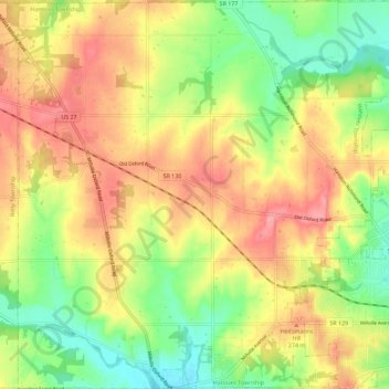
Name: Hanover Township topographic map, elevation, terrain.

Location: Hanover Township, Butler County, Ohio, United States (39.39114 -84.70345 39.47907 -84.59021)

Average elevation: 245 m

Minimum elevation: 188 m

Maximum elevation: 303 m

Other topographic maps

Click on a map to view its topography, its elevation and its terrain.

South Highlands

United States > Ohio > Butler County > Middletown

Average elevation: 214 m

Hughes

United States > Ohio > Butler County

Average elevation: 237 m

Busenbark

United States > Ohio > Butler County

Average elevation: 202 m

Williamsdale

United States > Ohio > Butler County

Average elevation: 193 m

McGonigle

United States > Ohio > Butler County

Average elevation: 266 m

Astoria

United States > Ohio > Butler County

Average elevation: 263 m

West Chester

United States > Ohio > Butler County > West Chester

Average elevation: 231 m

Gear up for your next adventure:

Backpacking Tent - Lightweight tent for long-distance hiking trips
🥾Mountain Hiking Shoes - Shoes with superior grip for mountainous terrain
🧦Hiking Liner Socks - Thin base layer to prevent friction and blisters
🧤Thermal Hiking Gloves - Grip-enhanced gloves for cold-weather altitude trekking
🧴Insect Repellent - Protect yourself from bugs during outdoor adventures

As an Amazon Associate, this site earns from qualifying purchases at no extra cost to you.