
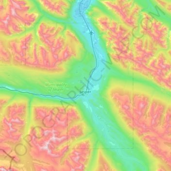
Municipality of Jasper topographic map
Interactive map
Click on the map to display elevation.
About this map
Name: Municipality of Jasper topographic map, elevation, terrain.
Average elevation: 1,789 m
Minimum elevation: 997 m
Maximum elevation: 3,110 m
Other topographic maps
Click on a map to view its topography, its elevation and its terrain.
Canmore
Canada > Alberta > Division No. 15
Canmore, Division No. 15, Alberta, T1W 2H4, Canada
Average elevation: 1,565 m
Lake Louise
Canada > Alberta > Division No. 15
Lake Louise, Division No. 15, Alberta, Canada
Average elevation: 1,617 m
Johnston Creek
Canada > Alberta > Division No. 15
Johnston Creek, Division No. 15, Alberta, Canada
Average elevation: 2,126 m
Rawson Lake
Canada > Alberta > Division No. 15
Rawson Lake, Division No. 15, Alberta, Canada
Average elevation: 2,162 m
Lac des Arcs
Canada > Alberta > Division No. 15 > Lac des Arcs
Lac des Arcs, Division No. 15, Alberta, Canada
Average elevation: 1,347 m
Mildred Lake
Canada > Alberta > Division No. 15 > Municipality of Jasper
Mildred Lake, Municipality of Jasper, Division No. 15, Alberta, Canada
Average elevation: 1,046 m
Chain Lakes Provincial Park
Canada > Alberta > Division No. 15
Chain Lakes Provincial Park, Division No. 15, Alberta, Canada
Average elevation: 1,365 m
Ghost Lake
Canada > Alberta > Division No. 15
Ghost Lake, Division No. 15, Alberta, Canada
Average elevation: 1,241 m
Eagle Hill
Canada > Alberta > Division No. 15
Eagle Hill, Division No. 15, Alberta, Canada
Average elevation: 1,576 m
Etherington Creek Provincial Recreation Area
Canada > Alberta > Division No. 15
Etherington Creek Provincial Recreation Area, Etherington-Baril Ridge Route, Division No. 15, Alberta, Canada
Average elevation: 1,749 m
Little Elbow Provincial Recreation Area
Canada > Alberta > Division No. 15
Little Elbow Provincial Recreation Area, Big Elbow Trail, Division No. 15, Alberta, Canada
Average elevation: 1,672 m
Second Lake
Canada > Alberta > Division No. 15 > Municipality of Jasper
Second Lake, Municipality of Jasper, Division No. 15, Alberta, Canada
Average elevation: 1,155 m
Scarab Peak
Canada > Alberta > Division No. 15
Scarab Peak, Division No. 15, Alberta, Canada
Average elevation: 2,357 m
Copper Mountain
Canada > Alberta > Division No. 15
Copper Mountain, Division No. 15, Alberta, Canada
Average elevation: 2,280 m
Pyramid Mountain
Canada > Alberta > Division No. 15 > Municipality of Jasper
Pyramid Mountain, Municipality of Jasper, Division No. 15, Alberta, Canada
Average elevation: 2,152 m
Banff National Park
Canada > Alberta > Division No. 15
Banff National Park, Improvement District No. 9, Alberta, Canada
Average elevation: 1,848 m
Pilot Mountain
Canada > Alberta > Division No. 15
Pilot Mountain, Division No. 15, Alberta, Canada
Average elevation: 2,313 m
Toronto Peak
Canada > Alberta > Division No. 15
Toronto Peak, Division No. 15, Alberta, Canada
Average elevation: 2,423 m
Highwood Pass
Canada > Alberta > Division No. 15
Highwood Pass, Division No. 15, Alberta, Canada
Average elevation: 2,364 m
Mînî Thnî
Canada > Alberta > Division No. 15
Mînî Thnî, Division No. 15, Alberta, Canada
Average elevation: 1,241 m
Upper Kananaskis Lake
Canada > Alberta > Division No. 15
Upper Kananaskis Lake, Division No. 15, Alberta, Canada
Average elevation: 1,775 m
Dead Man's Flats
Canada > Alberta > Division No. 15
Dead Man's Flats, Division No. 15, Alberta, T1W 2V4, Canada
Average elevation: 1,424 m
Athabasca Glacier
Canada > Alberta > Division No. 15
Athabasca Glacier, Division No. 15, Alberta, Canada
Average elevation: 2,483 m
Columbia Icefield
Canada > Alberta > Division No. 15 > Area A (Kicking Horse/Kinbasket Lake)
Columbia Icefield, Area A (Kicking Horse/Kinbasket Lake), Division No. 15, Alberta, Canada
Average elevation: 2,484 m
Crowsnest Pass
Canada > Alberta > Division No. 15
Crowsnest Pass, Municipality of Crowsnest Pass, Division No. 15, Alberta, T0K 0E0, Canada
Average elevation: 1,512 m
Kananaskis Village
Canada > Alberta > Division No. 15
Kananaskis Village, Division No. 15, Alberta, Canada
Average elevation: 1,590 m
Prairie Mountain
Canada > Alberta > Division No. 15
Prairie Mountain, Division No. 15, Alberta, Canada
Average elevation: 1,836 m
Crowfoot Glacier Viewpoint
Canada > Alberta > Division No. 15
Crowfoot Glacier Viewpoint, Icefields Parkway, Division No. 15, Alberta, Canada
Average elevation: 2,084 m
Moose Mountain
Canada > Alberta > Division No. 15
Moose Mountain, Division No. 15, Alberta, Canada
Average elevation: 2,104 m
Parker Ridge
Canada > Alberta > Division No. 15
Parker Ridge, Division No. 15, Alberta, Canada
Average elevation: 2,019 m