Geolocate

Rome topographic map

Click on the map to display elevation.

About this map

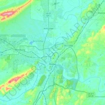
Name: Rome topographic map, elevation, terrain.

Location: Rome, Floyd County, Georgia, United States (34.19316 -85.27894 34.35650 -85.11225)

Average elevation: 211 m

Minimum elevation: 161 m

Maximum elevation: 457 m

Other topographic maps

Click on a map to view its topography, its elevation and its terrain.

Lake Hicks

United States > Georgia > Floyd County > Rome

Average elevation: 196 m

Green

United States > Georgia > Floyd County

Average elevation: 272 m

Floyd Springs

United States > Georgia > Floyd County

Average elevation: 226 m

Cave Spring

United States > Georgia > Floyd County

Average elevation: 237 m

Green

United States > Georgia > Floyd County > Green

Average elevation: 272 m

Gear up for your next adventure:

🧥Waterproof Jacket - Lightweight rain jackets for hiking and outdoor activities
🧦Hiking Liner Socks - Thin base layer to prevent friction and blisters
🧦Hiking Socks - Moisture-wicking and comfortable socks for long hikes
🧢Beanie Hat - Keep your head warm in cold weather
🔋Lithium AA Batteries - Long-lasting power that performs in extreme cold

As an Amazon Associate, this site earns from qualifying purchases at no extra cost to you.