Geolocate

Green topographic map

Click on the map to display elevation.

About this map

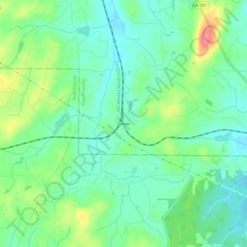
Name: Green topographic map, elevation, terrain.

Location: Green, Floyd County, Georgia, United States (34.06843 -85.16856 34.10843 -85.12856)

Average elevation: 272 m

Minimum elevation: 247 m

Maximum elevation: 324 m

Other topographic maps

Click on a map to view its topography, its elevation and its terrain.

Lake Hicks

United States > Georgia > Floyd County > Rome

Average elevation: 196 m

Rome

United States > Georgia > Floyd County

Average elevation: 211 m

Rome

United States > Georgia > Floyd County

Average elevation: 211 m

Rome

United States > Georgia > Floyd County

Average elevation: 211 m

Cave Spring

United States > Georgia > Floyd County

Average elevation: 237 m

Cave Spring

United States > Georgia > Floyd County

Average elevation: 235 m

Gear up for your next adventure:

🔭Compact Binoculars - Lightweight optics for scouting trails and wildlife
🔭Outdoor Binoculars - Lightweight binoculars for birdwatching and hiking
🧴Insect Repellent - Protect yourself from bugs during outdoor adventures
🧼Travel Hand Sanitizer - Keep hands clean when water is scarce
🥾Waterproof Hiking Boots - Boots keeping your feet dry in wet conditions

As an Amazon Associate, this site earns from qualifying purchases at no extra cost to you.