Geolocate

Floyd Springs topographic map

Click on the map to display elevation.

About this map

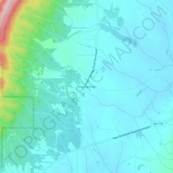
Name: Floyd Springs topographic map, elevation, terrain.

Location: Floyd Springs, Floyd County, Georgia, 30105, United States (34.40676 -85.17495 34.44676 -85.13495)

Average elevation: 226 m

Minimum elevation: 185 m

Maximum elevation: 462 m

Other topographic maps

Click on a map to view its topography, its elevation and its terrain.

Rome

United States > Georgia > Floyd County

Average elevation: 211 m

Cave Spring

United States > Georgia > Floyd County

Average elevation: 235 m

Lake Hicks

United States > Georgia > Floyd County > Rome

Average elevation: 196 m

Rome

United States > Georgia > Floyd County

Average elevation: 211 m

Rome

United States > Georgia > Floyd County

Average elevation: 211 m

Cave Spring

United States > Georgia > Floyd County

Average elevation: 237 m

Gear up for your next adventure:

🩹Compact First Aid Kit - Pre-packed essentials for common trail injuries
🗺️Topographic Maps - Detailed maps to explore trails, mountains, and wilderness areas
🧥Insulated Jacket - Keep warm in cold outdoor conditions
🧥Ultralight Puffy Jacket - Maximum warmth that packs down to the size of an orange
🥾Hiking Boots - Sturdy boots providing ankle support and traction on rugged trails

As an Amazon Associate, this site earns from qualifying purchases at no extra cost to you.