Geolocate

Ningguo topographic map

Click on the map to display elevation.

About this map

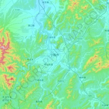
Name: Ningguo topographic map, elevation, terrain.

Location: Ningguo, Xijin Subdistrict, Ningguo, Anhui, China (30.47536 118.82673 30.79536 119.14673)

Average elevation: 158 m

Minimum elevation: 25 m

Maximum elevation: 942 m

Gear up for your next adventure:

🛌Down Sleeping Bag - Superior warmth-to-weight ratio for cold nights
🔦UV Flashlight - Detect minerals or specific insects in the dark
Bushcraft Tarp - Versatile emergency shelter or gear protection
🧭GPS Handheld Device - Reliable GPS navigation for outdoor adventures
💡Solar Camping Lamp - Eco-friendly lighting for campsites

As an Amazon Associate, this site earns from qualifying purchases at no extra cost to you.