Geolocate

Nineveh topographic map

Interactive map

Click on the map to display elevation.

About this map

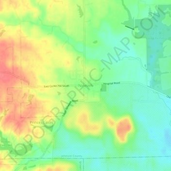
Name: Nineveh topographic map, elevation, terrain.

Location: Nineveh, Johnson County, Indiana, United States (39.34227 -86.10471 39.38227 -86.06471)

Average elevation: 238 m

Minimum elevation: 210 m

Maximum elevation: 273 m

Other topographic maps

Click on a map to view its topography, its elevation and its terrain.

Trafalgar

United States > Indiana > Johnson County

Trafalgar, Johnson County, Indiana, United States

Average elevation: 257 m

Greenwood

United States > Indiana > Johnson County

Greenwood, Johnson County, Indiana, United States

Average elevation: 245 m

Bargersville

United States > Indiana > Johnson County

Bargersville, Johnson County, Indiana, 46106, United States

Average elevation: 243 m

Edinburgh

United States > Indiana > Johnson County

Edinburgh, Johnson County, Indiana, United States

Average elevation: 205 m

Stones Crossing

United States > Indiana > Johnson County > Greenwood

Stones Crossing, Greenwood, Johnson County, Indiana, 46143, United States

Average elevation: 238 m

Green Valley

United States > Indiana > Johnson County > Greenwood

Green Valley, Greenwood, Johnson County, Indiana, 46143, United States

Average elevation: 239 m

Franklin

United States > Indiana > Johnson County

Franklin, Johnson County, Indiana, 46131, United States

Average elevation: 230 m