Geolocate

New Whiteland topographic map

Click on the map to display elevation.

About this map

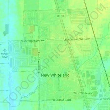
Name: New Whiteland topographic map, elevation, terrain.

Location: New Whiteland, Johnson County, Indiana, United States (39.54943 -86.11587 39.57213 -86.08363)

Average elevation: 245 m

Minimum elevation: 236 m

Maximum elevation: 253 m

Other topographic maps

Click on a map to view its topography, its elevation and its terrain.

Samaria

United States > Indiana > Johnson County

Average elevation: 243 m

Samaria

United States > Indiana > Johnson County

Average elevation: 243 m

Amity

United States > Indiana > Johnson County

Average elevation: 214 m

Samaria

United States > Indiana > Johnson County

Average elevation: 243 m

Banta

United States > Indiana > Johnson County > Bargersville

Average elevation: 232 m

Gear up for your next adventure:

🛌Insulated Sleeping Pad - Critical thermal barrier between you and the cold ground
Bushcraft Tarp - Versatile emergency shelter or gear protection
🧢Hiking Sun Hat - Wide-brimmed protection for exposed mountain ridges
🧤Rechargeable Heated Gloves - Extreme warmth for Canadian winter expeditions
🔋Lithium AA Batteries - Long-lasting power that performs in extreme cold

As an Amazon Associate, this site earns from qualifying purchases at no extra cost to you.