Geolocate

Edinburgh topographic map

Click on the map to display elevation.

About this map

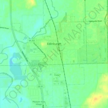
Name: Edinburgh topographic map, elevation, terrain.

Location: Edinburgh, Johnson County, Indiana, United States (39.33215 -85.98600 39.36909 -85.94281)

Average elevation: 205 m

Minimum elevation: 194 m

Maximum elevation: 220 m

Other topographic maps

Click on a map to view its topography, its elevation and its terrain.

Nineveh

United States > Indiana > Johnson County

Average elevation: 238 m

Green Valley

United States > Indiana > Johnson County > Greenwood

Average elevation: 239 m

Gear up for your next adventure:

🚲Handlebar Phone Mount - View topographic-map.com live while cycling
🧊Portable Cooler - Keep food and drinks cold during outdoor adventures
🔭Outdoor Binoculars - Lightweight binoculars for birdwatching and hiking
🕯️Camping Lantern - Illuminates your entire campsite with high-efficiency LEDs
🧴Sunscreen SPF - Broad-spectrum sunscreen for outdoor activities

As an Amazon Associate, this site earns from qualifying purchases at no extra cost to you.