Geolocate

Heugrumbach topographic map

Click on the map to display elevation.

About this map

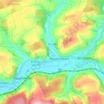
Name: Heugrumbach topographic map, elevation, terrain.

Location: Heugrumbach, Arnstein, Landkreis Main-Spessart, Bayern, 97450, Deutschland (49.95947 9.92694 50.00173 9.96465)

Average elevation: 259 m

Minimum elevation: 197 m

Maximum elevation: 350 m

Other topographic maps

Click on a map to view its topography, its elevation and its terrain.

Gear up for your next adventure:

🛰️Satellite Messenger - Emergency communication for areas with no cell service
🛌Down Sleeping Bag - Superior warmth-to-weight ratio for cold nights
💡Compact LED Flashlight - Powerful and portable flashlight for outdoor use
🪑Ultralight Camping Stool - Compact seating for rest stops during long hikes
🧥Softshell Hiking Jacket - The perfect balance of wind protection and breathability

As an Amazon Associate, this site earns from qualifying purchases at no extra cost to you.