Geolocate

Pierson topographic map

Click on the map to display elevation.

About this map
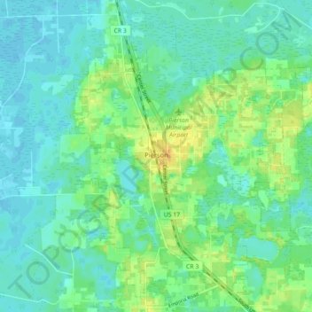
Name: Pierson topographic map, elevation, terrain.

Location: Pierson, Volusia County, Florida, 32180, United States (29.20373 -81.48978 29.27440 -81.40170)

Average elevation: 14 m

Minimum elevation: 5 m

Maximum elevation: 32 m

Other topographic maps

Click on a map to view its topography, its elevation and its terrain.
Deltona

United States > Florida > Volusia County > Deltona

Average elevation: 12 m

Enterprise

United States > Florida > Volusia County

Average elevation: 7 m

Shelby Lake

United States > Florida > Volusia County > Deltona

Average elevation: 24 m

Riverside

United States > Florida > Volusia County > DeLand

Average elevation: 6 m

Barberville

United States > Florida > Volusia County

Average elevation: 12 m

Glenwood

United States > Florida > Volusia County > DeLand

Average elevation: 21 m

DeLeon Spring

United States > Florida > Volusia County

Average elevation: 12 m

Daisy Lake

United States > Florida > Volusia County

Average elevation: 6 m

Glencoe

United States > Florida > Volusia County > Glencoe

Average elevation: 8 m

Lorraine Lake

United States > Florida > Volusia County > Deltona

Average elevation: 20 m

Alamana

United States > Florida > Volusia County

Average elevation: 11 m

Gear up for your next adventure:

🥾Waterproof Hiking Boots - Essential footwear for rugged terrain and wet Canadian trails
🥾Hiking Gaiters - Protect legs and shoes from mud, snow, and debris
🔭Compact Binoculars - Lightweight optics for scouting trails and wildlife
🩹Compact First Aid Kit - Pre-packed essentials for common trail injuries
🕶️Polarized Sunglasses - Reduces glare from snow and water at high elevations

As an Amazon Associate, this site earns from qualifying purchases at no extra cost to you.