Geolocate

Fulkerson topographic map

Click on the map to display elevation.

About this map

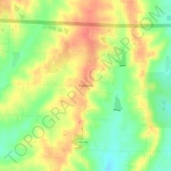
Name: Fulkerson topographic map, elevation, terrain.

Location: Fulkerson, Johnson County, Missouri, United States (38.83445 -94.10911 38.87445 -94.06911)

Average elevation: 298 m

Minimum elevation: 267 m

Maximum elevation: 324 m

Other topographic maps

Click on a map to view its topography, its elevation and its terrain.

Knob Noster

United States > Missouri > Johnson County

Average elevation: 247 m

Holden

United States > Missouri > Johnson County

Average elevation: 262 m

Kingsville

United States > Missouri > Johnson County

Average elevation: 272 m

Warrensburg

United States > Missouri > Johnson County

Average elevation: 240 m

Big Creek

United States > Missouri > Johnson County

Average elevation: 262 m

Knob Noster

United States > Missouri > Johnson County

Average elevation: 247 m

Warrensburg

United States > Missouri > Johnson County

Average elevation: 240 m

Gear up for your next adventure:

🚲MTB Frame Bag - Carry tools and maps directly on your bicycle frame
🥾Trekking Poles - Adjustable trekking poles to reduce knee stress and improve stability
🛰️Satellite Messenger - Emergency communication for areas with no cell service
🥾Approach Boots - Comfortable boots for hiking and climbing approaches
🩹Moleskin Blister Pads - Direct protection for painful foot pressure points

As an Amazon Associate, this site earns from qualifying purchases at no extra cost to you.