Geolocate

Warrensburg topographic map

Click on the map to display elevation.

About this map

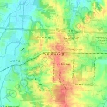
Name: Warrensburg topographic map, elevation, terrain.

Location: Warrensburg, Johnson County, Missouri, 64093, United States (38.73754 -93.76427 38.78703 -93.68746)

Average elevation: 240 m

Minimum elevation: 214 m

Maximum elevation: 277 m

Other topographic maps

Click on a map to view its topography, its elevation and its terrain.

Fulkerson

United States > Missouri > Johnson County

Average elevation: 298 m

Pittsville

United States > Missouri > Johnson County

Average elevation: 270 m

Gear up for your next adventure:

🧢Hiking Sun Hat - Wide-brimmed protection for exposed mountain ridges
💧Collapsible Water Bottle - Space-saving water bottle for outdoor activities
🧢Hiking Hat - Sun-protective and breathable hats for long treks
🧰Emergency Multi-Tool - Compact multi-tool for outdoor survival
🔭Outdoor Binoculars - Lightweight binoculars for birdwatching and hiking

As an Amazon Associate, this site earns from qualifying purchases at no extra cost to you.