Geolocate

Knob Noster topographic map

Click on the map to display elevation.

About this map

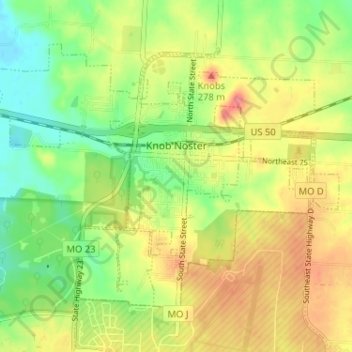
Name: Knob Noster topographic map, elevation, terrain.

Location: Knob Noster, Johnson County, Missouri, 65336, United States (38.74362 -93.59302 38.78112 -93.52881)

Average elevation: 247 m

Minimum elevation: 215 m

Maximum elevation: 281 m

Other topographic maps

Click on a map to view its topography, its elevation and its terrain.

Fulkerson

United States > Missouri > Johnson County

Average elevation: 298 m

Pittsville

United States > Missouri > Johnson County

Average elevation: 270 m

Gear up for your next adventure:

🚑Survival Whistle - Signal for help across long distances in mountains
🔪Outdoor Multitool - Versatile tool for repairs and food prep in the wild
🧴Insect Repellent - Protect yourself from bugs during outdoor adventures
🧢Sun Protection Cap - Breathable cap to protect from sun exposure
🥾Waterproof Hiking Shoes - Durable shoes for wet and rugged trails

As an Amazon Associate, this site earns from qualifying purchases at no extra cost to you.