Geolocate

Pittsville topographic map

Click on the map to display elevation.

About this map

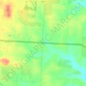
Name: Pittsville topographic map, elevation, terrain.

Location: Pittsville, Johnson County, Missouri, United States (38.83056 -94.01022 38.87056 -93.97022)

Average elevation: 270 m

Minimum elevation: 244 m

Maximum elevation: 299 m

Other topographic maps

Click on a map to view its topography, its elevation and its terrain.

Knob Noster

United States > Missouri > Johnson County

Average elevation: 247 m

Holden

United States > Missouri > Johnson County

Average elevation: 262 m

Kingsville

United States > Missouri > Johnson County

Average elevation: 272 m

Warrensburg

United States > Missouri > Johnson County

Average elevation: 240 m

Big Creek

United States > Missouri > Johnson County

Average elevation: 262 m

Knob Noster

United States > Missouri > Johnson County

Average elevation: 247 m

Warrensburg

United States > Missouri > Johnson County

Average elevation: 240 m

Gear up for your next adventure:

🔪Outdoor Multitool - Versatile tool for repairs and food prep in the wild
🧦Hiking Socks - Moisture-wicking and comfortable socks for long hikes
🥾Trail Running Shoes - Lightweight and durable shoes for trail running
Lightweight Backpacking Tent - Compact tent for efficient hiking trips
🔭Compact Monocular - One-handed bird watching and trail spotting

As an Amazon Associate, this site earns from qualifying purchases at no extra cost to you.